High and Low Lights of North Shields
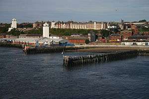
The High and Low Lights of North Shields which are also known as the Fish Quay High and Low Lights are a series of historic leading lights that were constructed near Fish Quay in North Shields, Tyne and Wear in the United Kingdom. The first pair of lighthouses were erected here in the 16th century by the Guild of the Blessed Trinity of Newcastle-upon-Tyne. By following a course which kept the two lights aligned, pilots were able to navigate along the Tyne, avoiding the dangerous Shields Bar and the Black Middens.[1]
Earliest lights
.jpg)
In 1536, a charter of Henry VIII gave permission to the Guild of the Blessed Trinity (which is known today as Trinity House of Newcastle) to build and embattle a pair of towers on the north bank of the River Tyne to serve as leading lights for safe navigation at the mouth of the river.[2] The granting of the charter coincided with Henry's policy of dissolving England's monasteries and in 1539 he gave the monastic church of the town's Blackfriars monastery to the Guild, which used its stonework to build the two towers.[3]
Work began on the towers the following year: they were built on high and low ground either side of Pow burn, which flows into the Tyne at 'the Narrows' (the narrowest point of the river mouth). A keeper was paid 20 shillings a year to keep a tallow candle alight in each tower every night for a certain number of hours either side of high tide.[3] To fund the provision and maintenance of these lights the Guild was empowered to levy dues on every ship entering the port (initially 2d per English vessel and 4d per foreign vessel).
In 1608 a further ordinance was issued by James I requiring Newcastle's Trinity House to maintain a pair of lighthouses at North Shields. The towers were increased in height at around this time; they are depicted on Ralph Gardner's map of 1655, still with their battlements (they were built with a defensive as well as a navigational purpose in mind).[3]
The changing position of sandbanks in the mouth of the river meant that the lights had likewise to change position from time to time. To try to address this, the lighthouses were replaced in 1658 by moveable wooden structures; these proved unreliable, however, and in the 1680s Newcastle's Trinity House was seeking funds to repair the stone towers.[4]
In 1672 the Low Light found itself enclosed by Clifford's Fort, constructed that year to help defend the Tyne from coastal attack. A postern in the fort wall provided access to the lighthouse; however, in the years that followed a number of disputes arose between Trinity House and the Governor of the Fort. These came to a head in 1726 when a new Governor's House was built on the site, which obscured the light. It seems likely that this is what prompted the rebuilding of both lights in 1727.[5]
Old High and Low Lights
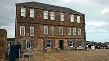
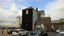 The 18th century Old Low Light | |
| Location |
North Shields Fish Quay Tyne and Wear England United Kingdom |
|---|---|
| Coordinates | 55°00′35″N 1°26′00″W / 55.00972°N 1.43333°W |
| Year first constructed | 1727 |
| Deactivated | 1810 |
| Construction | brick tower |
| Tower shape | rectilinear |
| Managing agent | Tyne & Wear Building Preservation Trust |
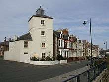 The 18th century Old High Light | |
| Location |
North Shields Fish Quay Tyne and Wear England United Kingdom |
|---|---|
| Coordinates | 55°00′34″N 1°26′13″W / 55.009341°N 1.436871°W |
| Year first constructed | 1727 |
| Deactivated | 1810 |
| Construction | brick tower |
| Tower shape | square parallelepiped tower with lantern on the roof attached to a dwelling |
| Markings / pattern | white tower |
| ARLHS number | ENG-299 |
| Managing agent | private residence[6] |
Initially, the 1727 High and Low Lights were each lit by three tallow candles.[7] Copper reflectors were added in 1736, and in 1773 the candles were replaced by oil lamps.[8] The Low Light was repaired and remodelled in 1733 and again in 1775 when the second floor was added.[4] By 1805 the lights were no longer aligned with river channel and Newcastle Trinity House began building a new pair of lights in 1808
Decommissioning and aftermath
When the New High and Low Lights were commissioned in 1810 the old lights were taken out of service and the white façade of the low light was painted black (to prevent it being confused with the new light when viewed from the water). In due course both Old Lights were converted by Trinity House into almshouses;[9] the Old Low Light, with the addition of a pitched roof, reopened as Trinity Alms House in 1830.[5]
At some later date the Old High Light became a private dwelling, and it remains so today; it is a grade II listed building.[10] The Old Low Light is also grade II listed[11] and, as part of Clifford's Fort, stands within a Scheduled Ancient Monument.[12] It served as a fish warehouse during the 20th century; saved from dereliction in 1988, it became a training centre for the Deep Sea Fisheries Association and latterly was occupied by the Maritime Volunteer Service. By the early 21st century the building was in a poor state of repair, but it was comprehensively refurbished after the MVS departed in 2011 and a modern annexe with viewing platform was added. The Old Low Light subsequently opened to the public in 2014 as a museum and community resource; it contains a ground-floor café, a permanent exhibition on the first floor (telling the history of the lighthouses, Clifford's Fort and Fish Quay) and an event space above it.[13]
New High and Low Lights
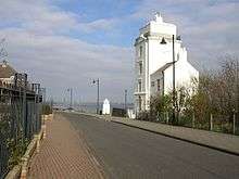
Work on the new lights was begun in 1807; both were designed for Trinity House, Newcastle-upon-Tyne, by local architect John Stokoe (1756–1836). Both towers are of white-painted ashlar, the High Light of four storeys, the Low Light of six, with curved windows; in each case the east face of the tower, facing the sea, is left plain and windowless (except on the lantern stage at the top where the lights shone out to sea). Above the lantern stage is a curved roof topped by a chimney.[9] The lights were first lit in 1810. Each has a house attached for its keepers: that on the Low Light is dated 1816, while that on the High Light has a plaque with the Trinity House arms recording its rebuilding in 1860.[9]
Decommissioning
In the late 1990s the lighthouse at Herd Groyne on the opposite bank of the Tyne had a sector light installed for navigation into Tynemouth and along the river, whereupon the High and Low Lights were decommissioned and the buildings sold for housing.[8] The towers, however, continue to serve as daymarks for vessels entering the Tyne and both are listed buildings.[14][15]
Each New Light stands close to its predecessor: the Low Lights are on Fish Quay and the High Lights on Tyne Street, on the ridge above the quay.[9]
 Fish Quay Low Light looking down at the mouth of the Tyne | |
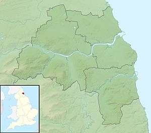 Tyne and Wear | |
| Location |
North Shields Fish Quay Tyne and Wear England United Kingdom |
|---|---|
| Coordinates | 55°00′33″N 1°26′04″W / 55.009124°N 1.434512°W |
| Year first constructed | 1807 |
| Deactivated | 1990s |
| Construction | stone tower |
| Tower shape | massive square parallelepiped tower with small lantern on the roof |
| Markings / pattern | white tower |
| Height | 85 feet (26 m) |
| Focal height | 82 feet (25 m) |
| Range | 13 nautical miles (24 km) |
| Admiralty number | A2703 |
| ARLHS number | ENG-300 |
| Managing agent | Port of Tyne[16] |
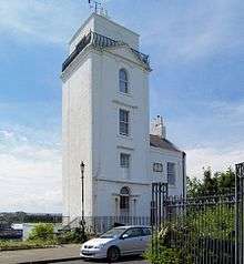 Fish Quay High Light attached to adjacent building | |
| Location |
North Shields Fish Quay Tyne and Wear England United Kingdom |
|---|---|
| Coordinates | 55°00′31″N 1°26′16″W / 55.008725°N 1.437907°W |
| Year first constructed | 1807 |
| Deactivated | 1990s |
| Construction | stone tower |
| Tower shape | square parallelepiped tower with small lantern on the roof attached to a building |
| Markings / pattern | white tower |
| Height | 57 feet (17 m) |
| Focal height | 138 feet (42 m) |
| Range | 16 nautical miles (30 km) |
| Characteristic | F W |
| Admiralty number | A2703.1 |
| ARLHS number | ENG-301 |
| Managing agent | Port of Tyne[17] |
See also
References
- ↑ North Sea Pilot, Part III, Hydrographic Dept, 1897, p. 84
- ↑ Stevenson, David (2013) [1959], The World's Lighthouses Before 1820, Dover, p. 22, ISBN 1306367425
- 1 2 3 "North Shields, Old Low Light (medieval)". Tyne & Wear SiteLines (Historic Environment Record). Newcastle City Council. Retrieved 13 September 2016.
- 1 2 "North Shields: an archaeological assessment and strategy" (PDF). Tyne & Wear Historic Towns Survey. Newcastle City Council. Retrieved 7 August 2016.
- 1 2 "Our history". Old Low Light. Retrieved 7 August 2016.
- ↑ "Fish Quay Old". Lighthouse Directory. University of North Carolina at Chapel Hill. Retrieved 5 June 2016.
- ↑ "North Shields, Old Low Light". Tyne & Wear SiteLines. Retrieved 13 September 2016.
- 1 2 Jones, Robin (2014). Lighthouses of the North East Coast. Halsgrove.
- 1 2 3 4 Pevsner, Nikolaus; Richmond, Ian; Grundy, John; McCombie, Grace; Welfare, Humphrey; Ryder, Peter (1992). The Buildings of England: Northumberland. Pevsner Architectural Guides: Buildings of England Series. Yale University Press. pp. 528–9. ISBN 0300096380.
- ↑ "Beacon House Trinity Buildings Number 1". Listed building description. Historic England. Retrieved 7 August 2016.
- ↑ "Clifford's Fort Trinity House Almshouses and Boundary Stone attached". Listed building description. Historic England. Retrieved 7 August 2016.
- ↑ "Clifford's Fort". Scheduled Ancient Monument listing. Historic England. Retrieved 7 August 2016.
- ↑ "How we started". Old Low Light. Retrieved 7 August 2016.
- ↑ "New High Light". Listed building description. Historic England. Retrieved 7 August 2016.
- ↑ "New Low Light". Listed building description. Historic England. Retrieved 7 August 2016.
- ↑ Fish Quay Low (Range Front) The Lighthouse Directory. University of North Carolina at Chapel Hill. Retrieved 5 June 2016
- ↑ Fish Quay Old The Lighthouse Directory. University of North Carolina at Chapel Hill. Retrieved 5 June 2016
Sources
- History of the Old Low Light, The Net, 19 March 2012
- Northern Counties Archaeological Services (May 2010), The Old Low Light, No. 54 Clifford’s Fort, North Shields, Tyne and Wear; (NZ 363081 684810) Conservation Statement (PDF), North Tyneside Council
- Appleby Miller, R.N. (October 1930), "History of the High and Low Lights", Smith’s Dock Journal: 249–255
- Lawrence, Danny (2011), The Making of Stan Laurel: Echoes of a British Boyhood, McFarland, ISBN 978-0786485154
External links
| Wikimedia Commons has media related to Fish Quay High Light. |
| Wikimedia Commons has media related to Fish Quay Low Light. |
| Wikimedia Commons has media related to Fish Quay Old High Light. |
Coordinates: 55°00′22″N 1°26′34″W / 55.006148°N 1.442692°W