Harrison Nunatak


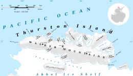
Harrison Nunatak (72°32′S 96°2′W / 72.533°S 96.033°WCoordinates: 72°32′S 96°2′W / 72.533°S 96.033°W) is a snow-covered nunatak, with rock exposure to the southeast, located 4 nautical miles (7 km) south of Savage Glacier in the extreme southeastern part of Thurston Island, Antarctica. It was discovered on helicopter flights from the USS Burton Island (AGB-1) and USS Glacier (AGB-4) during the U.S. Navy Bellingshausen Sea Expedition in February 1960, and was named by the Advisory Committee on Antarctic Names for Henry T. Harrison, Jr., a U.S. Weather Bureau meteorologist with the Byrd Antarctic Expedition in 1928–30.[1][2]
Maps
- Thurston Island – Jones Mountains. 1:500000 Antarctica Sketch Map. US Geological Survey, 1967.
- Antarctic Digital Database (ADD). Scale 1:250000 topographic map of Antarctica. Scientific Committee on Antarctic Research (SCAR), 1993–2016.
References
- ↑ "Harrison Nunatak". Geographic Names Information System. United States Geological Survey. Retrieved 2012-05-28.
- ↑ Alberts, Fred G., ed. (June 1995). Geographic Names of the Antarctic (PDF) (second ed.). United States Board on Geographic Names. p. 314. Retrieved 2012-04-05.
![]() This article incorporates public domain material from the United States Geological Survey document "Harrison Nunatak" (content from the Geographic Names Information System).
This article incorporates public domain material from the United States Geological Survey document "Harrison Nunatak" (content from the Geographic Names Information System).