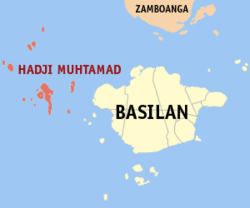
Hadji Muhtamad, Basilan
| Hadji Muhtamad | |
|---|---|
| Municipality | |
 Location within Basilan province | |
.svg.png) Hadji Muhtamad Location within the Philippines | |
| Coordinates: 6°38′N 121°37′E / 6.63°N 121.62°ECoordinates: 6°38′N 121°37′E / 6.63°N 121.62°E | |
| Country | Philippines |
| Region | Autonomous Region in Muslim Mindanao (ARMM) |
| Province | Basilan |
| District | Lone district of Basilan |
| Founded | August 25, 2007 |
| Barangays | 10 (see Barangays) |
| Government [1] | |
| • Type | Sangguniang Bayan |
| • Mayor | Jamar A. Mansul |
| Population (2015 census)[2] | |
| • Total | 25,085 |
| • Voter (2016)[3] | 8,135 |
| Time zone | PST (UTC+8) |
| ZIP code | 7301 |
| IDD : area code | +63 (0)62 |
| PSGC | 150712000 |
Hadji Muhtamad, officially the Municipality of Hadji Muhtamad (Filipino: Bayan ng Hadji Muhtamad), is a municipality in the province of Basilan in the Autonomous Region in Muslim Mindanao (ARMM) of the Philippines. The population was 25,085 at the 2015 census.[2] In the 2016 election, it had 8,135 registered voters.[3]
Its territory includes the Pilas Islands and surrounding islets, west of Basilan Island.
Hadji Muhtamad was created out of the 10 barangays of Lantawan that were not on Basilan Island, through Muslim Mindanao Autonomy Act No. 200,[4] which was subsequently ratified in a plebiscite held on August 25, 2007.[5]
Barangays
Hadji Muhtamad is politically subdivided into 10 barangays.[6]
| PSGC | Barangay | Population | ±% p.a. | ||
|---|---|---|---|---|---|
| 2015[2] | 2010[7] | ||||
| 150712001 | Baluk-baluk | 6.3% | 1,585 | 1,063 | +7.90% |
| 150712002 | Dasalan | 11.8% | 2,970 | 1,518 | +13.63% |
| 150712003 | Lubukan | 13.0% | 3,260 | 1,730 | +12.82% |
| 150712004 | Luukbongsod | 7.7% | 1,928 | 988 | +13.58% |
| 150712005 | Mananggal | 3.2% | 800 | 763 | +0.91% |
| 150712006 | Palahangan | 7.7% | 1,920 | 787 | +18.51% |
| 150712007 | Panducan | 6.6% | 1,652 | 1,087 | +8.30% |
| 150712008 | Sangbay Big | 14.1% | 3,549 | 1,330 | +20.55% |
| 150712009 | Sangbay Small | 11.6% | 2,900 | 1,416 | +14.62% |
| 150712010 | Tausan | 18.0% | 4,521 | 1,567 | +22.35% |
| Total | 25,085 | 12,249 | +14.62% | ||
Demographics
| Population census of Hadji Muhtamad | ||||||||||||||||
|---|---|---|---|---|---|---|---|---|---|---|---|---|---|---|---|---|
|
| |||||||||||||||
| Source: PSA[2][7][8] | ||||||||||||||||
In the 2015 census, Hadji Muhtamad had a population of 25,085.[2]
In the 2016 election, it had 8,135 registered voters.[3]
References
- ↑ "Municipality". Quezon City, Philippines: Department of the Interior and Local Government. Retrieved 31 May 2013.
- 1 2 3 4 5 "ARMM - Autonomous Region in Muslim Mindanao". Census of Population (2015): Total Population by Province, City, Municipality and Barangay (Report). PSA. Retrieved 20 June 2016.
- 1 2 3 "2016 National and Local Elections Statistics". Commission on Elections. 2016.
- ↑ "Muslim Mindanao Autonomy Act No. 200; An Act Creating the Municipality of Hadji Muhtamad in the Province of Basilan and for Other Purposes" (PDF). Regional Legislative Assembly, Autonomous Region in Muslim Mindanao. Archived from the original (PDF) on 4 February 2016. Retrieved 27 January 2016.
- ↑ "Five (5) New Cities, Two (2) Municipalities and a Barangay created in the Third Quarter of 2007". National Statistical Coordination Board. 13 November 2007. Archived from the original on 24 November 2007. Retrieved 10 November 2016.
- ↑ "Municipal: Hadji Muhtamad, Basilan". PSGC Interactive. Quezon City, Philippines: Philippine Statistics Authority. Retrieved 8 January 2016.
- 1 2 "ARMM - Autonomous Region in Muslim Mindanao". Census of Population and Housing (2010): Total Population by Province, City, Municipality and Barangay (Report). NSO. Retrieved 29 June 2016.
- ↑ "ARMM - Autonomous Region in Muslim Mindanao". Census of Population (1995, 2000 and 2007): Total Population by Province, City and Municipality (Report). NSO. Archived from the original on 11 November 2011.
 |
Sulu Sea |  | ||
| Sulu Sea | |
Lantawan | ||
| ||||
| | ||||
| Sulu Sea |
