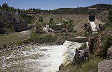
Guernsey Dam
| Guernsey Dam | |
|---|---|
 | |
| Location | Platte County, Wyoming, USA |
| Coordinates | 42°17′25″N 104°45′49″W / 42.290167°N 104.763737°WCoordinates: 42°17′25″N 104°45′49″W / 42.290167°N 104.763737°W |
| Construction began | 1925[1] |
| Opening date | 1928 |
| Operator(s) | U.S. Bureau of Reclamation |
| Dam and spillways | |
| Impounds | North Platte River |
| Height | 135 feet (41 m)[2] |
| Length | 560 feet (170 m)[2] |
| Reservoir | |
| Creates | Guernsey Reservoir |
Guernsey Dam is an earthfill dam on the North Platte River in Platte County in the U.S. State of Wyoming. The dam creates Guernsey Reservoir, the last of the 5 major reservoirs on the North Platte River in Wyoming. The dam contains a hydroelectric plant capable of 6.4 megawatts of electricity.[1] The total capacity of the reservoir is 71,040 acre feet (87,630,000 m3) of water which is used mainly for irrigation. Morrison-Knudsen (Now URS Corporation) and Utah Construction Company constructed Guernsey Dam and the hydroelectric plant as part of the North Platte Project to provide irrigation to eastern Wyoming and western Nebraska. Guernsey helps control the river flow and stores water released from the project's primary storage upstream at Pathfinder Reservoir. About 8 miles (13 km) miles downstream of the dam the Whalen Diversion Dam diverts water into the Fort Laramie and Interstate Canals that service farms in Wyoming and Nebraska.
The reservoir is surrounded by Guernsey State Park.
See also
References
- 1 2 "Platte River Basin Water Atlas".
- 1 2 "Guernsey Dam". U.S. Bureau of Reclamation.