Greater Lowell
| Greater Lowell | |
|---|---|
| Region of Massachusetts | |
|
Red represents the City of Lowell, Dark Blue represents the Greater Lowell area, Light Blue represent the The New England city and town area Division Lowell-Billerica-Chelmsford, Purple represents both. | |
| Country |
|
| State |
|
| Towns and cities | Billerica, Chelmsford, Dracut, Dunstable, Groton, Lowell, Pepperell, Tewksbury, Tyngsborough, Westford |
| Largest city | Lowell, Massachusetts (108,522) (2010 census) |
| Population | 299,550 (2,010 census) |
Greater Lowell is the name given to the city of Lowell, Massachusetts and its suburbs which are found in Northern Middlesex County, Massachusetts, the Merrimack Valley, and Southern New Hampshire.
Towns
The Greater Lowell area as defined as the Lowell Metropolitan area consists of the towns of Billerica, Chelmsford, Dracut, Dunstable, Groton, Lowell, Pepperell, Tewksbury, Tyngsborough, and Westford.[1] The town of Pelham, New Hampshire may also be included in Greater Lowell.[2]
The New England city and town area Division Lowell-Billerica-Chelmsford contains some towns that can be considered part of Greater Lowell, Ashby, Ayer, Billerica, Chelmsford, Dracut, Groton, Littleton, Lowell, Shirley, Tewksbury, Townsend, Tyngsborough, Westford, and Harvard in Massachusetts and Pelham in New Hampshire.[3]
Demographics
The towns of Greater Lowell in Massachusetts have a combined population of 299,550 based on the 2010 census.[4] Including the town of Pelham, Greater Lowell has 312,447 inhabitants.[4]
Culture and Education
The city of Lowell is a cultural and institutional center for the region. It is home to the Tsongas Center at UMass Lowell and the Lowell National Historical Park, which preserves the region's legacy as an early textile manufacturing center during the Industrial Revolution. The University of Massachusetts Lowell and a campus of Middlesex Community College are located in the city as well, as are Lowell General Hospital and Saints Medical Center, the regional hospitals.
Lowell is home to both the Superior and a District Court for Northern Middlesex County and is technically a county seat, although Massachusetts counties are largely historical in function. Culturally, many residents of Greater Lowell have deep roots in the city itself, tend to be more blue collar, and speak with an urban Boston accent. Politically, Greater Lowell is split politically while the region as a whole is more likely to vote for a conservative candidate than other parts of the state, the city of Lowell is more likely to vote liberally.[5][6][7]
Economy


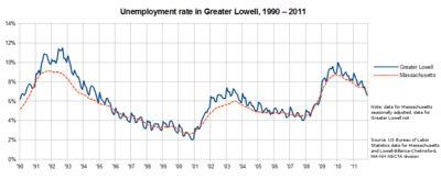
The economy of Greater Lowell is closely tied to that of Greater Boston. Outside of the services, health, and retail sectors, major employers are in high technology and defense, with a still-shrinking manufacturing sector.
Suburban sprawl and serious economic hardships have reduced the role Lowell plays in its suburbs over the decades. The entire region is often considered a component of the much larger Greater Boston area, as Lowell is only 25 miles from downtown Boston. Suburban office parks, shopping malls, and the severe decline of heavy industry in New England have pulled the economic focus away from the once great industrial and commercial base in Lowell itself. Additionally, the population of Lowell is at 1900 levels despite large growth among the suburban population.
External links
- Lowell Sun newspaper
- Chamber of Commerce
- Northern Middlesex Council of Governments
- The Greater Merrimack Valley Convention & Visitors Bureau
- Lowell at city-data.com
References
- ↑ "METROPOLITAN AREA and Components of FMR AREA within STATE" (PDF). Mass.gov. Retrieved 22 November 2014.
- ↑ "New Hampshire Commuting Patterns - 1990 U.S. Census" (PDF). .nhes.nh.gov. Retrieved 22 November 2014.
- ↑ "Current Lists of Metropolitan and Micropolitan Statistical Areas and Delineations". census.gov. Retrieved 22 November 2014.
- 1 2 "Community Facts". American Fact Finder. Retrieved 22 November 2014.
- ↑ http://www.massinc.org/index.php?id=610
- ↑ http://www.boston.com/news/globe/ideas/articles/2006/06/04/the_state_im_in/
- ↑ "2014 Election Results, showing regional voting habits". wbur.org. Retrieved 22 November 2014.
Coordinates: 42°40′00″N 71°20′00″W / 42.66667°N 71.33333°W