Zasechnaya cherta


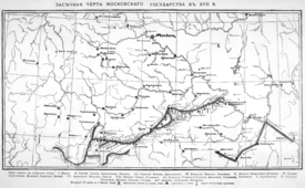
Zasechnaya cherta (Russian: Большая засечная черта, loosely translated as Great Abatis Line or Great Abatis Border) was a chain of fortification lines, created by Grand Duchy of Moscow and later the Tsardom of Russia to protect it from the raids of the Crimean Tatars who, rapidly moving along the Muravsky Trail, ravaged the southern provinces of the country during a series of the Russo-Crimean Wars.[1] It also served as a border between the Muscovite State and the steppe nomads. As a fortification line stretching for hundreds kilometers, the Great Abatis Border is analogous to the Great Wall of China and the Roman Limes.
Abatis is a military term for a field fortification made by cutting down trees. The line was built from the felled trees that were arranged as a barricade. It was also fortified by ditches and earth mounds, palisades, watch towers and natural features like lakes and swamps. The width of the abatis mounts up to several hundred meters. In the most dangerous places the abatis was doubled, trebled etc., the gates and small wooden fortresses were created to check the passers.[2] Peasants who lived nearby were forbidden to settle or cut wood in the area, but were obliged by authorities to spend part of their time supporting and renewing the fortifications.[3] In the autumn, large areas of steppegrass beyond the line were burnt to deny raiders fodder.
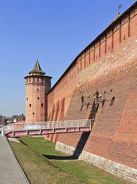
Stone and wooden kremlins of the towns were also included in the Great Abatis Line. Among these towns were: Serpukhov, Kolomna, Zaraysk, Tula, Ryazan, Belyov. Other fortresses in the line were smaller ostrogs.

There were a large number of fortification lines in Russian history and it is difficult to get good information on them. The lines naturally moved south as the Russian state expanded. The earliest reference to abatis fortifications appears to be in a Novgorod chronicle of 1137-1139. Abatis lines began appearing in southern Rus' in the 13th century. The 'Great Abatis Line' extended from Bryansk to Meschera and was nominally completed in 1566. It was guarded by a local militia of about 35,000 in the second half of the 16th century. Another source gives an annual callup of 65,000. Behind the line was a mobile army headquartered in Tula (6,279 men in 1616, 17,005 in 1636).
There are several notable lines. The oldest one (finished by 1563-1566) ran from Nizhniy Novgorod along the Oka River to Kozelsk,[4] and was built by Ivan the Terrible. The next one, built a while later, followed the line Alatyr - Orel - Novgorod Seversky - Putivl. Feodor I of Russia had built the abatis on the line Livny - Kursk - Voronezh - Belgorod. Simbirsk line[5] was constructed about 1640, and continued the Belgorod line from Tambov to Simbirsk on the Volga River.[6] In 1730-31 the Kama line separated Kazan from the Bashkirs. From about 1736 a Samara-Orenburg line closed in the Baskirs from the south.
See also
References
- ↑ Abatis Lines with maps at cultinfo.ru
- ↑ Зеленые стены России, Т. Беляева, "Наука и Жизнь", №5 2004 год.
- ↑ Article with photos at defensive-works.ru Archived August 14, 2011, at the Wayback Machine.
- ↑ Бобровский М.В. Козельские засеки (эколого-исторический очерк). Калуга: Изд-во Н. Бочкаревой, 2002. 92 с., with maps and illustrations (in Russian)
- ↑ Simbirsk Archeology Archived July 21, 2010, at the Wayback Machine.
- ↑ Khodarkovsky,Michael, "Russia's Steppe Frontier", 2002.
External links
- Recent photos from one of the regions of the Abatis Border
- Recent photos of the Simbirsk line
- Photos from the Zakamskaya line
- Photo 1024x768 (Kolomna Kremlin)
- Photo 1024x768 (Kolomna Kremlin, Pyatnitskie Gate)