Gorgopotamos (river)
| Gorgopotamos | |
|---|---|
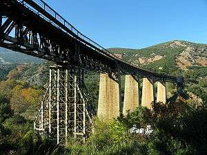
 Bridge over the Gorgopotamos | |
| Native name | Γοργοπόταμος |
| Country | Greece |
| Basin | |
| Main source | Mount Oeta, Phthiotis |
| River mouth |
Spercheios 10 m (33 ft) 38°51′22″N 22°25′3″E / 38.85611°N 22.41750°ECoordinates: 38°51′22″N 22°25′3″E / 38.85611°N 22.41750°E |
| Physical characteristics | |
| Length | approx. 15 km (9.3 mi) |
The Gorgopotamos (Greek: Γοργοπόταμος, "the rushing river") is a river in the southern part of Phthiotis, Central Greece, Greece not far from the border with Phocis. The river is host to the Ellinopygosteos fish (Pungitius hellenicus).
Geography
The Gorgopotamos rises 4 km north of Pavliani and west of Koumaritsi in the Oiti mountains with two streams. The river flows through a steep forested valley. It passes under OSE's Athens-Thessaloniki railway line and through the village Gorgopotamos, where it enters the plains. It empties into the river Spercheios near Ydromilos, 5 km southwest of Lamia.
History
The railway bridge over the river is famous for one of the biggest sabotage acts of World War II, "Operation Harling".[1] A British mission and 150 Greek partisans blew it up on 25 November 1942, cutting off German supplies being transported between Athens and Thessaloniki (mostly headed for Africa). The blast destroyed two of the six piers of the bridge, which have now been replaced with steel girders. The area around the bridge is a monument.
References
- ↑ Pawelek, Peter. "Operation Harling: Destruction of the Gorgopotamos Rail Bridge, 1942". Combatsim.com. Retrieved 27 May 2012.