Geçitköy Dam
| Geçitköy Dam | |
|---|---|
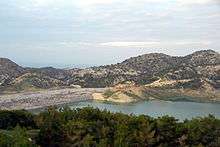
 View of the Geçitköy Dam | |
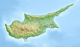
 Location of Geçitköy Dam in Cyprus | |
| Country | Cyprus (under control of Northern Cyprus) |
| Location | Lapithos |
| Coordinates | 35°19′45.33″N 33°4′15.34″E / 35.3292583°N 33.0709278°ECoordinates: 35°19′45.33″N 33°4′15.34″E / 35.3292583°N 33.0709278°E |
| Purpose | Municipal and irrigation water |
| Status | Operational |
| Construction began | 2012 |
| Opening date | 2014 |
| Dam and spillways | |
| Type of dam | Embankment, rock-fill clay core |
| Impounds | Mandara River |
| Height | 65 m (213 ft) |
| Reservoir | |
| Total capacity | 35,000,000 m3 (28,000 acre·ft) |
The Geçitköy Dam is a rock-fill dam on the Mandara River about 8 km (5.0 mi) west of the town of Lapithos in Cyprus. The dam is located in the de facto territory of Northern Cyprus. It was originally completed as the Dağdere Dam in 1989 but between 2012 and 2014 it was raised and expanded into its current form. The dam is part of the Northern Cyprus Water Supply Project and receives water not only from the river but via an undersea pipeline connected to the Alaköprü Dam, located near the southern shores of Mersin Province, Turkey. Construction on main works for the dam began on 30 March 2012 and it was completed on 7 March 2014. The new dam increased the reservoir capacity from 1,800,000 m3 (1,500 acre·ft) to 35,000,000 m3 (28,000 acre·ft).[1][2] Water from Turkey first entered the reservoir on 17 October 2015. From there it is transferred via pumps to Girne which lies to the east.[3]
References
- ↑ "Geçitköy" (in Turkish). Website Cyprus. Retrieved 30 October 2015.
- ↑ "Geçitköy Dam" (in Turkish). Dolsar. Retrieved 30 October 2015.
- ↑ "Turkish water begins to flow to northern Cyprus as vast pipeline project goes onstream". EuroNews. 17 October 2015. Retrieved 30 October 2015.