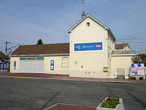
Gare d'Ermont-Halte
 The station in 2007 | |||||||||||
| Location | Ermont, France | ||||||||||
| Coordinates | 48°59′23″N 2°15′48″E / 48.98972°N 2.26333°ECoordinates: 48°59′23″N 2°15′48″E / 48.98972°N 2.26333°E | ||||||||||
| Owned by | SNCF | ||||||||||
| Line(s) | Ermont-Eaubonne–Valmondois railway | ||||||||||
| Platforms | 2 | ||||||||||
| Tracks | 2 | ||||||||||
| Construction | |||||||||||
| Parking | 200 | ||||||||||
| Other information | |||||||||||
| Fare zone | 4 (Carte Orange) | ||||||||||
| History | |||||||||||
| Opened | 1876 | ||||||||||
| Traffic | |||||||||||
| Passengers (2003) | 7,500–15,000[1] | ||||||||||
| Services | |||||||||||
| |||||||||||
The Gare d'Ermont-Halte (Ermont-Halte station) is a railway station located in the commune of Ermont (Val-d'Oise department), France. The station is served by Transilien Paris Nord (line H) trains from Paris to Persan-Beaumont via Saint-Leu-la-Forêt. In 2003 there were between 7,500 and 15,000 passengers per day. The station has free parking for 200 vehicles.[1] Ermont-Halte is located on the line from Ermont-Eaubonne to Valmondois, that was opened in 1876. The line was electrified in 1970.[2]
See also
References
| Wikimedia Commons has media related to Gare d'Ermont - Halte. |
- 1 2 STIF - Atlas des transports publics Île-de-France (French) Public Transportation Atlas of the Île-de-France
- ↑ La Vie du Rail magazine June 28, 1970 - Électrification de la gare de Montsoult-Maffliers. (Electrification of Gare de Montsoult-Maffliers)
This article is issued from Wikipedia - version of the 4/16/2015. The text is available under the Creative Commons Attribution/Share Alike but additional terms may apply for the media files.