Fort Lincoln (Washington, D.C.)
| Fort Lincoln | |
|---|---|
| Neighborhood of Washington, D.C. | |
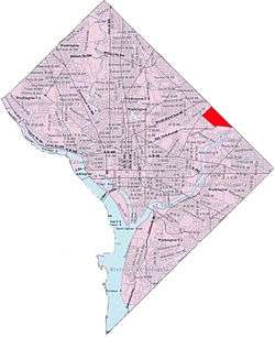
 Fort Lincoln within the District of Columbia | |
| Country | United States |
| District | Washington, D.C. |
| Ward | Ward 5 |
| Government | |
| • Councilmember | Kenyan McDuffie |
| Area | |
| • Total | 0.47 sq mi (1.2 km2) |
Fort Lincoln is a neighborhood located in northeastern Washington, D.C. It is bounded by Bladensburg Road to the northwest, Eastern Avenue to the northeast, New York Avenue NE to the south, and South Dakota Avenue NE to the southwest. The town of Colmar Manor, Maryland, is across Eastern Avenue from the Fort Lincoln neighborhood, as is the Fort Lincoln Cemetery.
The name Fort Lincoln was originally used for a Civil War Fort in adjacent Prince George's County, Maryland, across the D.C. line from the Washington neighborhood bearing its name.
Neighborhood
This northeast Washington neighborhood is home to the Fort Lincoln "New Town" development constructed in the 1960s and 1970s.[1] This neighborhood is currently the home of Cathy Lanier, Chief of the D.C. Metropolitan Police.[2] In 2011 another 42 acres of the wetland forest park was sold to make a shopping center.[3][4]
Civil war site and cemetery
The Fort Lincoln area includes a Civil War-era fort, Fort Lincoln, constructed in 1861 for the defense of Washington. The fort is now part of Fort Lincoln Cemetery, and can be visited.[5][6]
Fort Lincoln Park
| Fort Lincoln | |
|---|---|
|
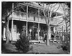
Brigade headquarters at Fort Lincoln, circa 1861-1869 | |
 Location within Washington, D.C. | |
| Location | Washington, D.C. |
| Coordinates | 38°55′26″N 76°57′22″W / 38.924°N 76.956°WCoordinates: 38°55′26″N 76°57′22″W / 38.924°N 76.956°W |
| Website |
tclf |
Fort Lincoln is a Civil War earthwork in the Fort Lincoln neighborhood. It was constructed in 1861 for the defense of Washington. The fort was built along the District line in adjacent Prince George's County, Maryland, directly along the line of the Baltimore and Ohio Railroad between Baltimore, Maryland, and Washington.
The fort had a perimeter of 466 yards (426 m), and places for 34 guns, including one 100-pound Parrott rifle.[7]
The fort is within Fort Lincoln Cemetery, and can be visited.[8][6]
References
- ↑ Ellen Hoffman (26 September 1969). "New Towners The Voiceless Marylanders, Columbia Citizens Seeking More Say". The Washington Post.
- ↑ "Hope Stirs In Fort Lincoln Growth, New Neighbor Inspire Pocket of D.C. to Believe in Change," By Clarence Williams, The Washington Post, Apr 30, 2007, p. B01.
- ↑ Kelly (December 13, 2011). "Shops at Dakota Crossing and Costco to Start Now, Open Next Year". DCmud. DCRE, INC. Retrieved December 14, 2011.
- ↑ "Fort Lincoln Wetlands". Anacostia Riverkeeper. Waterkeeper Alliance. 2010. Retrieved December 27, 2011.
- ↑ ""Battery Jameson, Fort Lincoln"" Waymark
- 1 2 Maryland Historical Trust, Inventory Form for State Historic Sites Inventory - Battery Jameson (PG-68-15a)
- ↑ Cooling III, Benjamin Franklin; Owen II, Walton H. (6 October 2009). Mr. Lincoln's Forts: A Guide to the Civil War Defenses of Washington. Scarecrow Press. pp. 203–208. ISBN 978-0-8108-6307-1.
- ↑ ""Battery Jameson, Fort Lincoln"" Waymark
External links
| Wikimedia Commons has media related to Fort Lincoln. |
- "Fort Lincoln: Finding a Leafy Enclave," By Linda Wheeler, The Washington Post, July 18, 1992
- Fort Lincoln Historical Marker, The Maryland Historical Marker Database
 |
Woodridge | Mount Rainier, Maryland | Colmar Manor, Maryland |  |
| Langdon | |
|||
| ||||
| | ||||
| Gateway | |
Anacostia River |
