Falkenstein (Saxon Switzerland)
| Falkenstein | |
|---|---|
|
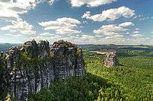
The Falkenstein seen from the Schrammsteine | |
| Highest point | |
| Elevation | 381.2 m above sea level (HN) (1,251 ft) |
| Coordinates | 50°55′06″N 14°12′04″E / 50.91833°N 14.20111°ECoordinates: 50°55′06″N 14°12′04″E / 50.91833°N 14.20111°E |
| Geography | |
| Parent range | Saxon Switzerland |
| Geology | |
| Age of rock | Cretaceous |
| Mountain type |
Sandstone Stage d Rock summit |
| Climbing | |
| First ascent | 1864 by Schandau gymnasts |
| Easiest route | Schusterweg III |
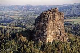
The Falkenstein is one of the best known climbing peaks in Saxon Switzerland. It is situated near the rocky Schrammsteine ridge southeast of the town of Bad Schandau. The Falkenstein is nearly 90 m high and consists of sandstone. In the Middle Ages there were fortifications on top of the rock. Even today, the steps carved into the rock are still visible.
In 1864 the first ascent of the rock was made in modern times by gymnasts from Bad Schandau. This ascent, using the climbing route known now as the Turnerweg, is also seen as the "birthday" of Saxon rock-climbing. The peak of the Falkenstein can only be reached by skilled climbers. Nowadays more than 100 routes lead to the top. The most popular ascent is Schusterweg (III), which was first climbed by Dr. Oscar Schuster in 1893.
Other famous climbs on the 'Falkenstein' (with their Saxon rating grades) are the:
- Südriss (VIIa) - first ascent by Oliver Perry-Smith in 1913
- Direkte Westkante (VIIIb) - first ascent by Wulf Scheffler in 1956
- Buntschillernde Seifenblase (IXb) - first ascent by Bernd Arnold
Sources
- Der Falkenstein, Aus der Geschichte eines Kletterfelsens in der Sächsischen Schweiz, Neisse Verlag 2001, ISBN 3-934038-12-3


