Eilean Tigh
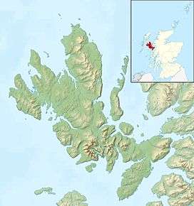
Eilean Tigh (Scottish Gaelic: Eilean Taighe) is a tidal island in the Sound of Raasay of Scotland, that lies between Rona and Raasay.
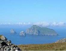
Approximately 54 hectares (130 acres) in extent, the island was once settled and the ruins of various structures are still visible at the south end.[3] "Eilean Tigh" is a Gaelic name that means "house island" or "home island".

Eilean Tigh from Raasay
It is a rugged island and the coastline is largely cliff-lined and rocky. Eilean Tigh is connected to the northern tip of neighbouring Raasay at low tides by a rocky ledge that crosses Caol Eilean Tigh.[4] Rona lies about 1 kilometre (0.62 mi) away across the straits of Caol Rona at the centre of which is tiny Eilean an Fhraoich (English: heather island). On the Rona side are Garbh Eilean (rough island) and Eilean Seamraig. Eilean Fladday is 2 kilometres (1.2 mi) to the south and Skye is some 6 kilometres (3.7 mi) to the west across the Sound.
There are good anchorages nearby off Eilean Fladday and Rona, but the nearest road stops at Arnish on Raasay, from where it is about a two-hour walk to Eilean Tigh.[4] The north western tip of the island is Rubha na Cloich' Uaine - the point of the green stone.
Notes
Coordinates: 57°30′40″N 6°0′10″W / 57.51111°N 6.00278°W / 57.51111; -6.00278
|
|---|
|
| Main settlements | |
|---|
|
Crofting townships
and settlements | |
|---|
|
| Mountains and hills | |
|---|
|
| History and prehistory | |
|---|
|
| Local culture | |
|---|
|
| Peninsulas | |
|---|
|
| Surrounding islands | |
|---|
|
| Other | |
|---|
|
|---|
|
| |
|
|
|
|
|
|
|
|
|
| Culture |
|---|
| | Shetland | |
|---|
| | Orkney | |
|---|
| | Outer Hebrides | |
|---|
| | Inner Hebrides | |
|---|
|
|
|
| Politics |
|---|
| | Local authorities | |
|---|
| | Serving MSPs | |
|---|
| | Serving MPs | |
|---|
| | Other | |
|---|
|
|
|
| Wildlife |
|---|
| | Fauna | |
|---|
| | Flora | |
|---|
| | Domesticated animals | |
|---|
|
|
|
|