Digital orthophoto quadrangle
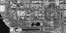
A digital orthophoto quadrangle[1] (DOQ) is aerial photography or satellite imagery that has been corrected so that its pixels are aligned with longitude and latitude lines, and have a narrowly defined region of coverage. This is a widely used format introduced by United States Geological Survey (USGS).[1] The correction technique is called image rectification and is a large part of photogrammetry.[2]
DOQs produced by the USGS cover an area measuring 7.5-minutes longitude by 7.5-minutes latitude (the same area covered by a USGS 1:24,000-scale topographic map, also known as a 7.5-minute quadrangle) or 3.75-minutes by 3.75-minutes. The second format is also known as a digital orthophoto quarter quadrangle (DOQQ) because each covers one quarter of a quadrangle (four 1:12,000-scale DOQQs display the same area as one 1:24,000-scale DOQ).[3][4] [5]
See also
References
- 1 2 "USGS GeoData Digital Orthophoto Quadrangles" (PDF). USGS Fact Sheet 057-01. United States Geological Survey. May 2001.
- ↑ "Introduction to Photogrammetry". The Aerial Archive. Institute for Prehistory and Protohistory of the University of Vienna.
- ↑ "USGS DOQ History". United States Geological Survey: Western Region. Retrieved April 24, 2012.
- ↑ "USGS 7.5-minute maps". United States Geological Survey: Eastern Geographic Science Center. Retrieved April 24, 2012.
- ↑ "DOQHEAD Toolkit". United States Geological Survey: Rocky Mountain Mapping Center. June 22, 1998.
External links
- U.S. Geological Survey Mapping in the 20th Century: 1980’s - Digital Orthophoto Quadrangles
- Birthplace of the DOQ — USGS Western Region