Demitz-Thumitz
| Demitz-Thumitz | ||
|---|---|---|
|
Elementary school | ||
| ||
 Demitz-Thumitz | ||
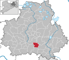
Location of Demitz-Thumitz within Bautzen district 
 | ||
| Coordinates: 51°8′N 14°15′E / 51.133°N 14.250°ECoordinates: 51°8′N 14°15′E / 51.133°N 14.250°E | ||
| Country | Germany | |
| State | Saxony | |
| District | Bautzen | |
| Government | ||
| • Mayor | Horst Wittholz | |
| Area | ||
| • Total | 21.07 km2 (8.14 sq mi) | |
| Population (2015-12-31)[1] | ||
| • Total | 2,704 | |
| • Density | 130/km2 (330/sq mi) | |
| Time zone | CET/CEST (UTC+1/+2) | |
| Postal codes | 01877 | |
| Dialling codes | 03594 | |
| Vehicle registration | BZ | |
| Website | www.demitz-thumitz.de | |
Demitz-Thumitz (Sorbian: Zemicy-Tumicy) is a municipality in the east of Saxony, Germany. It belongs to the district of Bautzen.
Geography
The municipality is situated at the edge of the Lausitzer Bergland (Lusatian Hills).
Villages
Several villages belong to the municipality:
- Demitz-Thumitz (Zemicy-Tumicy)
- Wölkau (Wjelkowy)
- Medewitz (Mjedźojz)
- Birkenrode (Brězyšćo)
- Rothnaußlitz (Čerwjene Noslicy)
- Cannewitz (Chanecy)
- Karlsdorf
- Pottschapplitz (Počaplicy)
- Pohla-Stacha (Palow-Stachow)
History
Within the German Empire (1871-1918), Demitz-Thumitz was part of the Kingdom of Saxony.
Transport
Demitz-Thumitz is located at the railroad line Dresden-Görlitz and the Bundesstraße 6 (Dresden-Bautzen).
References
This article is issued from Wikipedia - version of the 7/18/2015. The text is available under the Creative Commons Attribution/Share Alike but additional terms may apply for the media files.

