German South-West Africa
| German South-West Africa | ||||||||
| Deutsch-Südwestafrika | ||||||||
| German colony | ||||||||
| ||||||||
| ||||||||
 Green: German South-West Africa Dark Grey: Other German possessions Black: German Empire Note: The historical extent of German territories are depicted over present-day political borders. | ||||||||
| Capital | Windhoek (from 1891) | |||||||
| Languages | German (official), Herero, Afrikaans, Khoekhoe | |||||||
| Religion | Christianity, San religion | |||||||
| Political structure | Colony | |||||||
| Governor | ||||||||
| • | 1894–1905 | Theodor von Leutwein | ||||||
| • | 1905–1907 | Friedrich von Lindequist | ||||||
| • | 1907–1910 | Bruno von Schuckmann | ||||||
| • | 1910–1915 | Theodor Seitz | ||||||
| Historical era | Scramble for Africa | |||||||
| • | Established | 7 August 1884 | ||||||
| • | Genocide | 1904–1907 | ||||||
| • | Disestablished | 9 July 1915 | ||||||
| • | Treaty of Versailles | 1919 | ||||||
| Area | 835,100 km² (322,434 sq mi) | |||||||
| Currency | German South-West African mark | |||||||
| ||||||||
| Today part of | | |||||||
German South-West Africa (German: Deutsch-Südwestafrika, DSWA) was a colony of the German Empire from 1884 until 1915. With an area of 835,100 km², it was one and a half times the size of the mainland German Empire in Europe at the time.
In 1915, during the First World War, German South-West Africa was invaded by the Western Allies in the form of South African and British forces. After the war its administration was taken over by the Union of South Africa (part of the British Empire) and the territory was administered as South-West Africa under a League of Nations mandate. It became independent as Namibia in 1990.
Early settlements
Initial European contact with the areas which would become German South-West Africa came from traders and sailors, starting in January 1486 when Portuguese explorer Diogo Cão, possibly accompanied by Martin Behaim, landed at Cape Cross. However, for several centuries, European settlement would remain limited and temporary. In February 1805 the London Missionary Society established a small mission in Blydeverwacht, but the efforts of this group met with little success. In 1840 the London Missionary Society transferred all of its activities to the German Rhenish Missionary Society. Some of the first representatives of this organisation were Franz Heinrich Kleinschmidt (who arrived in October 1842) and Carl Hugo Hahn (who arrived in December 1842). They began founding churches throughout the territory. The Rhenish missionaries had a significant impact initially on culture and dress, and then later on politics. During the same time that the Rhenish missionaries were active, merchants and farmers were establishing outposts.
Early history
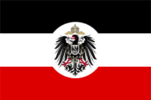
On 16 November 1882 a German merchant from Bremen, Adolf Lüderitz, requested protection for a station that he planned to build in South-West Africa, from Chancellor Bismarck. Once this was granted, his employee Heinrich Vogelsang purchased land from a native chief and established a city at Angra Pequena which was renamed Lüderitz. On 24 April 1884, he placed the area under the protection of Imperial Germany to deter British encroachment. In early 1884, the gunboat SMS Nautilus visited to review the situation. A favourable report from the government, and acquiescence from the British, resulted in a visit from the SMS Leipzig and SMS Elisabeth. The German flag was finally raised in South-West Africa on 7 August 1884. The German claims on this land were confirmed during the Conference of Berlin. In October, the newly appointed Commissioner for West Africa, Gustav Nachtigal, arrived on the SMS Möwe.[1]
In April 1885, the Deutsche Kolonialgesellschaft für Südwest-Afrika (German Colonial Society for Southwest Africa, known as DKGSWA) was founded with the support of German bankers (Gerson von Bleichröder, Adolph von Hansemann), industrialists (Count Guido Henckel von Donnersmarck) and politicians (Frankfurt mayor Johannes von Miquel). DKGSWA was granted monopoly rights to exploit mineral deposits.[2] The new Society soon bought the assets of Lüderitz's failing enterprises. Later, in 1908, diamonds were discovered. Thus along with gold, copper, platinum, and other minerals, diamonds became a major investment. Earlier, the colonial aim was to dispossess the indigenous peoples of their land, for use of German settlers, as well as be a source of raw materials and a market of German industrial products.[2]

Lüderitz drowned in 1886 while on an expedition to the Orange River. The company bought all of Lüderitz' land and mining rights, following Bismarck's policy that private rather than public money should be used to develop the colonies. In May, Heinrich Ernst Göring was appointed Commissioner and established his administration at Otjimbingwe. Then, on 17 April 1886, a law creating the legal system of the colony was passed, creating a dual system with laws for Europeans and different laws for natives.[3]

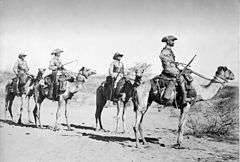
Over the next several years relations between the Germans and indigenous peoples continued to worsen. Additionally, the British settlement at Walvis Bay as well as numerous small farmers and missionaries were all involved in the area. A complex web of treaties, agreements and vendettas increased the unrest in the area. In 1888 the first group of Schutztruppen—colonial protectorate troops—arrived (they were sent secretly) to protect the base at Otjimbingwe. The Schutztruppe detachment consisted of two officers, five non-commissioned officers, and 20 black soldiers.
By the end of the year, the German commissioner Heinrich Ernst Göring was forced to flee to Walvis Bay after negotiations failed with a local tribe. Also, by the late 1880s, the South West Africa Company was nearly bankrupt and had to ask Bismarck for help and additional troops. By 1890 the colony was declared a Crown Colony and additional troops were sent to the area.[4] At the same time the colony grew through the acquisition of the Caprivi Strip in the northeast, which promised new trade routes. This territory was acquired through the Heligoland–Zanzibar Treaty between Britain and Germany.[5]
Almost simultaneously, in August through September 1892, the South West Africa Company, Ltd (SWAC) was established by the German, British, and Cape Colony governments, aided by financiers to raise the capital required to enlarge mineral exploitation (specifically, the Damaraland concession's copper deposit interests).
German South-West Africa was the only German colony where Germans settled in large numbers. German settlers were drawn to the colony by economic possibilities in diamond and copper mining, and especially farming. In 1902 the colony had 200,000 inhabitants, though only 2,595 were German, 1,354 were Afrikaner, and 452 were British. By 1914, 9,000 more German settlers had arrived. There were probably around 80,000 Herero, 60,000 Ovambo, and 10,000 Nama, who were disparagingly referred to as Hottentots.
Rebellion against German rule and genocide of the Herero and Namaqua


Through 1893 and 1894, the first "Hottentot Uprising" of the Nama and their legendary leader Hendrik Witbooi occurred. The following years saw many further local uprisings against German rule. Before the Herero and Namaqua Genocide of 1904–1907, the Herero and Nama had good reasons to distrust the Germans, culminating in the Khaua-Mbandjeru Rebellion. This rebellion, in which the Germans tried to control the Khaua by seizing their property by artificially imposing European legal views of property ownership, led to the largest of the rebellions, known as the Herero Wars (or Herero Genocide) of 1904.
Remote farms were attacked, and approximately 150 German settlers were killed. The Schutztruppe of only 766 troops and native auxiliary forces was, at first, no match for the Herero. The Herero went on the offensive, sometimes surrounding Okahandja and Windhoek, and destroying the railway bridge to Osona. Additional 14,000 troops, hastened from Germany under Lieutenant General Lothar von Trotha, crushed the rebellion in the Battle of Waterberg.
Earlier von Trotha issued an ultimatum to the Herero people, denying them the right of being German subjects and ordering them to leave the country, or be killed. To escape, the Herero retreated into the waterless Omaheke region, a western arm of the Kalahari Desert, where many of them died of thirst. The German forces guarded every water source and were given orders to shoot any adult male Herero on sight. Only a few Herero managed to escape into neighbouring British territories.[6]

The German official military report on the campaign lauded the tactics:
This bold enterprise shows up in the most brilliant light the ruthless energy of the German command in pursuing their beaten enemy. No pains, no sacrifices were spared in eliminating the last remnants of enemy resistance. Like a wounded beast the enemy was tracked down from one water-hole to the next, until finally he became the victim of his own environment. The arid Omaheke [desert] was to complete what the German army had begun: the extermination of the Herero nation.— Bley, 1971: 162
In late 1904, the Nama entered the struggles against the colonial power under their leaders Hendrik Witbooi and Jakobus Morenga, the latter often referred to as "the black Napoleon". This uprising was finally quashed during 1907–1908. In total, between 25,000 and 100,000 Herero, more than 10,000 Nama and 1,749 Germans died in the conflict.
After the official end of the conflict, the remaining natives, when finally released from detention, were subject to a policy of dispossession, deportation, forced labour, and racial segregation and discrimination in a system that in many ways anticipated apartheid. The genocide remains relevant to ethnic identity in independent Namibia and to relations with Germany.[7]
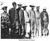
The Germans maintained a number of concentration camps in the colony during their war against the Herero and Nama peoples. Besides these camps the indigenous people were interned in other places. These included private businesses and government projects,[8] ships offshore,[9][10][11] Etappenkommando in charge of supplies of prisoners to companies, private persons, etc., as well as any other materials. Concentration camps implies poor sanitation and a population density that would imply disease.[12] Prisoners were used as slave labourers in mines and railways, for use by the military or settlers.[13][14][15]
The Herero and Namaqua genocide has been recognised by the United Nations and by the Federal Republic of Germany. On the 100th anniversary of the camp's foundation, German Minister for Economic Development and Cooperation Heidemarie Wieczorek-Zeul commemorated the dead on-site and apologised for the camp on behalf of Germany.[16][17]
 |  |  |  |
 |  |  |
First World War

During the First World War, South African troops opened hostilities with an assault on the Ramansdrift police station on 13 September 1914. German settlers were transported to prison camps near Pretoria and later in Pietermaritzburg. Because of the overwhelming superiority of the South African troops, the German Schutztruppe, along with groups of Afrikaner volunteers fighting in the Maritz Rebellion on the German side, offered opposition only as a delaying tactic. On 9 July 1915, Victor Franke, the last commander of the Schutztruppe, capitulated near Khorab.
Two members of the Schutztruppe, geography professors Fritz Jaeger and Leo Waibel, are remembered for their explorations of the northern part of German South West Africa, which became the book Contributions to the Geography of South West Africa (Beiträge zur Landeskunde von Südwestafrika).[18]
After the war, the territory came under the control of Britain, and then was made a South African League of Nations mandate. In 1990, the former colony became independent as Namibia, governed by the former liberation movement SWAPO.
German legacy
Many German names, buildings, and businesses still exist in the country, and about 30,000 people of German descent still live there. German is still widely used in Namibia, with the Namibian Broadcasting Corporation operating a German language radio station and broadcasting television news bulletins in German, while the daily newspaper Allgemeine Zeitung, founded in 1916, remains in publication.[19] Deukom, a satellite television service, offers television and radio channels from Germany.[20]
In addition, Lutheranism is the predominant Christian denomination in present-day Namibia.
See also
- List of colonial governors of South-West Africa
- List of former German colonies
- Postage stamps and postal history of German South-West Africa
- Germans of Namibia
- German Kamerun
- Togoland
- German East Africa
References
- Notes
- ↑ Chronology 1884 Section
- 1 2 "39-1885". Retrieved 12 May 2009.
- ↑ Chronology 1886 Section
- ↑ Chronology 1890 Section
- ↑ "Africa". Encyclopædia Britannica. 1. 1910. p. 343. Retrieved 10 February 2009.
- ↑ "Michael Mann – German South-West Africa: The Genocide of the Hereros, 1904-5". Retrieved 6 February 2009.
- ↑ Reinhart Kössler, and Henning Melber, "Völkermord und Gedenken: Der Genozid an den Herero und Nama in Deutsch-Südwestafrika 1904–1908," ("Genocide and memory: the genocide of the Herero and Nama in German South-West Africa, 1904–08") Jahrbuch zur Geschichte und Wirkung des Holocaust 2004: 37–75
- ↑ Casper Erichsen, "The angel of death has descended violently among them: Concentration camps and prisoners-of-war in Namibia, 1904–1908," African Studies Centre, Leiden, 2005, p. 49
- ↑ Erichsen, p. 23
- ↑ Erichsen, pp. 59, 111
- ↑ Erichsen, p. 76
- ↑ Erichsen, p. 113
- ↑ Casper Erichsen, "The angel of death has descended violently among them: Concentration camps and prisoners-of-war in Namibia, 1904–1908," African Studies Centre, Leiden, 2005, p. 43
- ↑ "The loads … are out of all proportion to their strength. I have often seen women and children dropping down, especially when engaged on this work, and also when carrying very heavy bags of grain, weighing from 100 to 160lbs." Erichsen, p. 58
- ↑ "Forcing women to pull carts as if they were animals was in tune with the treatment generally meted out to Herero prisoners in Lüderitz as elsewhere in the colony." Erichsen, p 84
- ↑ "Germany admits Namibia genocide," BBC News, 14 August 2004
- ↑ "Namibia – Genocide and the second Reich"
- ↑ Jaeger, Fritz; Leo Waibel (1920–1921). "Contributions to the Geography of South-West Africa". World Digital Library (in German). Retrieved 13 April 2014.
- ↑ Tools of the Regime: Namibian Radio History and Selective Sound Archiving 1979–2009, Basler Afrika Bibliographien, Presented at the Sound Archives Workshop, Basel, 4 September 2009
- ↑ Die DEUKOM Fernsehsender
- Bibliography
- Casper Erichsen, "The angel of death has descended violently among them": Concentration camps and prisoners-of-war in Namibia, 1904–1908, African Studies Centre, University of Leiden, 2005
Further reading
- Schnee, Dr.Heinrich, (former Governor of German East Africa), German Colonisation, Past and Future – The Truth about the German Colonies, George Allen & Unwin, London, 1926.
- Bullock, A.L.C., Germany's Colonial Demands, Oxford University Press, 1939.
- Hillebrand, Werner. "'Certain uncertainties', or venturing progressively into colonial apologetics?" Journal of Namibian Studies, 1. 2007. pp. 73–95. Online. Accessed 17 December 2011.
- Historicus Africanus: "Der 1. Weltkrieg in Deutsch-Südwestafrik 1914/15", Band I, Windhoek 2012, ISBN 978-99916-872-1-6
- Historicus Africanus: "Der 1. Weltkrieg in Deutsch-Südwestafrika 1914/15", Band II, "Naulila", Windhoek 2012, ISBN 978-99916-872-3-0
- Historicus Africanus. "Der 1. Weltkrieg in Deutsch-Südwestafrika 1914/15", Band III, "Kämpfe im Süden", Windhoek 2014, ISBN 978-99916-872-8-5
- Erich von Schauroth: "Liebes Väterchen...", Briefe aus dem Namaaufstand 1905–06, Windhoek 2008, ISBN 978-99945-68-29-1
- Karl Waldeck: "Gut und Blut für unsern Kaiser...", Windhoek 2010, ISBN 978-99945-71-55-0
External links
- Klaus Dierks' chronology of Namibia
- worldstatesmen.org (Namibia)
- The New Student's Reference Work/German Southwest Africa
- Debie LeBeau's Development work on Namibia
- "Contributions to the Geography of South-West Africa" from 1920–21 via the World Digital Library
Coordinates: 22°34′12″S 17°05′01″E / 22.57000°S 17.08361°E


