County of Sponheim
| County of Sponheim | ||||||||||||||||
| Grafschaft Sponheim (German) | ||||||||||||||||
| State of the Holy Roman Empire | ||||||||||||||||
| ||||||||||||||||
|
| ||||||||||||||||
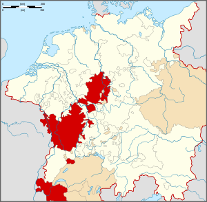
 Location of the County of Sponheim | ||||||||||||||||
| Capital | ||||||||||||||||
| Government | Principality | |||||||||||||||
| Historical era | Middle Ages | |||||||||||||||
| • | Established | the 11th century | ||||||||||||||
| • | Partitioned to Starkenburg and Kreuznach | about 1225 | ||||||||||||||
| • | Divided between Baden, Palatinate-Simmern-Zweibrücken-Birkenfeld and the Electoral Palatinate | 1437 | ||||||||||||||
| • | Joined Upper Rhenish Imperial Circle | 1500 | ||||||||||||||
| • | Annexed by the First French Empire | 1804 | ||||||||||||||
| ||||||||||||||||
.jpeg)
The County of Sponheim (German: Grafschaft Sponheim, former spelling: Spanheim, Spanheym) was an independent territory in the Holy Roman Empire which lasted from the 11th century until the early 19th century. The name comes from the municipality of Sponheim, where the counts had their original residence.
Geography
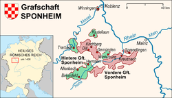
The territory was located roughly between the rivers Rhine, Moselle and Nahe, in the present state of Rhineland-Palatinate, around the Hunsrück region. It bordered the Electorate of Trier to the north and west, the Raugraviate, the Electorate of Mainz and the Electorate of the Palatinate to the east and the County of Veldenz to the south and west, among other states.
History
Beginnings
The family of Sponheim, or Spanheim (German: Spanheimer), is documented since the 11th century. There are two main branches which are certainly related, but whose exact relationship is still debated. The branch of the Dukes of Carinthia descends from Siegfried I, Count of Sponheim. The Rhenish branch which retained the County of Sponheim descends from Stephan I, Count of Sponheim.
The county originated from various inheritances which were united in the family's hands, including possessions from the Counties of Nellenburg and Stromberg and jurisdiction of the Gaugrafen of Trechirgau (Berthold-Bezelin dynasty). The Sponheim comital office is supposedly derived from the comital office of Trechirgau.[1] The family of the Counts of Sponheim founded the monastery of Sponheim in the 12th century, where in the 11th century a church had already been built. An abbot from Sponheim, Johannes Trithemius, chronicled the counts of Sponheim and accumulated a large collection of documents on the history of the area.
First divisions, Upper and Lower Counties, 13th to 15th centuries

Around 1225 the county was divided in two, with each portion ruled by a different branch of the House of Sponheim. The Sponheim-Starkenburg line ruled over the Upper, Hither or Farther County of Sponheim (Hintere Grafschaft Sponheim), based on Starkenburg, and the Sponheim-Kreuznach line over the Lower, Anterior or Fore County of Sponheim (Vordere Grafschaft Sponheim), based on Kreuznach.
This partition took place among the sons of Count Gottfried III of Sponheim, who died abroad while participating in the Fifth Crusade. Gottfried had married Adelheid of Sayn, sister of the last Count of Sayn, Henry III. His estate was divided between their three sons John I, Henry and Simon I. Simon, the youngest brother, received the Lower County of Sponheim and set as his residence castle Kauzenburg near Kreuznach. Henry married the heiress of Heinsberg, received a portion of the Sayn inheritance and founded the Sponheim line of the lords of Heinsberg. John became heir to Sayn and to the Upper County of Sponheim, residing first in Starkenburg Castle, and from 1350 at Grevenburg castle at Trarbach).
John I's sons divided their father's estate in 1265. Gottfried received the County of Sayn, whose direct heirs are today the counts of Sayn-Wittgenstein. Henry I, Count of Sponheim-Starkenburg became heir to the Upper County of Sponheim.
Both territories were extensively fortified throughout the centuries, as evidenced by the existence of around 21 castles or castle ruins, many of which can still be visited today.[note 1] Feuds with the neighbouring Electorates of Mainz and Trier were common, giving birth to southwestern German legends such as the tale of Michel Mort. The Upper and Lower Counties were also not always on good terms with each other regarding political affiliation. During the dispute between the German kings, Friedrich der Schöne and Ludwig the Bavarian, the Upper County supported Ludwig, while Lower Sponheim advocated for Frederick. Ludwig's victory resulted in political strengthening of Upper-Sponheim. Around that time the Lower County had itself been administratively divided between the brothers John II of Sponheim-Kreuznach and Simon II of Sponheim-Kreuznach, with Soonwald forest defining the boundary. Count Walram of Sponheim-Kreuznach reunited the Lower County. Walram became known as an active military leader involved in many actions, including inter-Sponheim ones.
Second divisions, joint regency
In 1417 the line Sponheim-Kreuznach became extinct and the line Sponheim-Starkenburg ruled alone for about 20 years over most of the whole county. Count Walram's granddaughter married Ruprecht Pipan, heir to the Electorate of the Palatinate, who died of disease after returning from the Battle of Nikopolis at the age of 21. The marriage was childless but nevertheless a small portion of the Lower County (less than 1/5) was granted as dowry to the Electors Palatine. In 1437 the line Sponheim-Starkenburg died out on the male succession, and the counties were managed in joint rule as a condominium by female line heirs from then on until the early 19th century. These rightful successors, which took on the title of Count at Sponheim (Graf zu Sponheim), were the Margraves of Baden, which descended from Mechtild of Sponheim, and the Counts of Veldenz, which descended from Loretta of Sponheim; both Mechtild and Loretta were daughters of Count John III of Sponheim-Starkenburg. The County of Veldenz was soon inherited by a collateral line of the Counts Palatine of the Rhine through the union of the heiress Anna of Veldenz with Count Palatine Stefan of Simmern-Zweibrücken. The rule of the Upper County of Sponheim was thus shared between Baden and Palatinate-Simmern-Zweibrücken or Palatinate-Birkenfeld; the rule of the Lower County of Sponheim roughly between Baden and the Electorate of the Palatinate.
Reformation
The Reformation was instituted in the County of Sponheim in the year 1557, led by Friedrich II, Count Palatine of Simmern. The county became an important Protestant territory, with exclaves on the Moselle like Enkirch, Trarbach or Winningen, bordering as it did the catholic Electorate of Trier. Warfare with neighbouring Catholic states would take place intermittently through the centuries, notably including the Thirty Years' War.
End of the County
After the Napoleonic Wars, most of the county became a part of Prussia,[note 2] and the region around Birkenfeld became part of Oldenburg. The ruling dynasties of Baden and Wittelsbach received extensive territories in exchange for the loss of Sponheim (compare also literature on the so-called "Sponheim Controversy" between Baden and Bavaria).
See also
- House of Sponheim
- List of Counts at Sponheim
- Margraviate of Baden
- County of Veldenz
- Electorate of the Palatinate
- House of Palatinate-Simmern
- House of Palatinate-Zweibrücken
- House of Palatinate-Birkenfeld
- Friedrich Karl von Tettenborn
References
- ↑ Jackman, Donald C.: Sponheim. Medieval German Counties. Medieval Prosopography. https://web.archive.org/web/20040205173219/www.personal.psu.edu/users/d/c/dcj121/prosop/counts/countyA/county11.htm . P. 4
Notes
- ↑ The County of Sponheim included throughout its history the following fortifications: Allenbach, Alt-Wolfstein, Argenschwang, Birkenfeld, Böckelheim, Dill, Tannenfels, Ebernburg, Frauenburg, Gemünden/Hunsrück, Grafendahn, Grevenburg, Gutenberg, Herrstein, Kastellaun, Koppenstein, Kreuznach, Naumburg, Sponheim, Starkenburg, Winterburg, Zollburg
- ↑ Grand Duchy of the Lower Rhine, 1822 Rhine Province
Further reading
- Jackman, Donald C.: Sponheim. Medieval German Counties. Medieval Prosopography.
- German language literature
- Bergholz, Thomas: Die Grafschaften Sponheim. In: Emil Sehling (Begr.): Die evangelischen Kirchenordnungen des 16. Jahrhunderts. Band 18: Rheinland-Pfalz I. Tübingen 2006, S. 619–684.
- Dotzauer, Winfried: Die Vordere Grafschaft Sponheim als pfälzisch-badisches Kondominium 1437–1707/8. Diss. phil. Universität Mainz 1963; Bad Kreuznach 1963
- Dotzauer, Winfried: Geschichte des Nahe-Hunsrück-Raumes von den Anfängen bis zur Französischen Revolution. Franz Steiner Verlag 2001, ISBN 3-515-07878-9
- Fey, Carola: Die Begräbnisse der Grafen von Sponheim. Untersuchungen zur Sepulkralkultur des mittelalterlichen Adels. Phil. Diss. Gießen, Mainz, 2003, ISBN 3-929135-41-8
- Hofmann, Johann: Trorbachische Ehren-Säul: Oder Geschichtliche Beschreibung förderst der Fürstl. Spanheymischen Ober-Amts-Statt Trorbach an der Mosel, Theils auch anderer Ohrt in derselben Gegend, sonderlich des dahin verbürgerten Haupt-fleckens Traben, Rößlin, Stuttgart 1669 (digitalized)
- Lehmann, Johann Georg: Die Grafschaft und die Grafen von Spanheim (Sponheim) der beiden Linien Kreuznach und Starkenburg. R. Voigtländer, Kreuznach 1869. Sändig Reprint, 1985, ISBN 978-3-253-02727-7 (digitalized at , , ed. 1869)
- Mötsch, Johannes: Die Grafschaften Sponheim. (Geschichtlicher Atlas der Rheinlande, Beiheft V/4), Köln: Rheinland-Verlag, 1992, ISBN 3-7927-1341-1
- Mötsch, Johannes: Genealogie der Grafen von Sponheim. In: Jahrbuch für westdeutsche Landesgeschichte. Band 13, 1987, S. 63–179, ISSN 0170-2025
- Mötsch, Johannes: Regesten des Archivs der Grafen von Sponheim 1065–1437. 5 Bände, Koblenz 1987–1991
- Mötsch, Johannes: Trier und Sponheim. In: Johannes Mötsch und Franz-Josef Heyen (Hrsg.): Balduin von Luxemburg. Erzbischof von Trier — Kurfürst des Reiches. Festschrift aus Anlaß des 700. Geburtsjahres. Mainz 1985, S. 357–389
- Stramberg, Johann Christian von; Weidenbach, Anton Joseph: Das Nahethal. Historisch und topographisch. 5 volumes. (Denkwürdiger und nützlicher rheinischer Antiquarius: Welcher die wichtisten und angenehmsten geographischen, historischen und politischen Merkwürdigkeiten des ganzen Rheinstroms, von seinem Ausflusse in das Meer bis zu seinem Ursprunge darstellt. Abt. II Bd. 16–20) Koblenz, Rud. Friedr. Hergt 1869–1871 (digitalized)
- Weydmann, Ernst: Geschichte der ehemaligen gräflich-sponheimischen Gebiete. Ein Beitrag zur deutschen Territorialgeschichte. Dissertation. Konstanz, Ackermann 1899
- Wild, Klaus Eberhard: Die Hintere Grafschaft Sponheim als pfälzisch-badische Gemeinsherrschaft (1437–1776). In: Mitteilungen des Heimatvereins Birkenfeld. 1972, Jg. 35, 3–32
- Wild, Klaus Eberhard: Zur Geschichte der Grafschaften Veldenz und Sponheim und der Birkenfelder Linien der pfälzischen Wittelsbacher. Birkenfeld 1982
External links
-
 Media related to County of Sponheim at Wikimedia Commons
 - (German) Mötsch, Johannes: Ein Kondominatsbesitz – Die Vordere und die Hintere Grafschaft Spohnheim (website by Wolfgang Morscheck) with good maps. (Archived by WebCite at http://www.webcitation.org/5kR0AUVHN?url=http://www.fiskalvorpost.de/moreu6i5.html)
- Höckmann, Thomas: Historical map of Rhineland-Palatinate 1789. Historical Atlas – Germany. (Archived by WebCite at http://www.webcitation.org/5kR0osgWA and http://www.webcitation.org/5kR17k3E4?url=http://www.hoeckmann.de/germany/sample09.htm)

