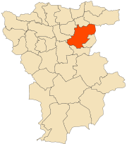
Mila, Algeria
| Mila ميلة | |
|---|---|
| city | |
|
Mila town | |
 city Mila in Mila Privince | |
 Mila city Mila in Mila Privince | |
| Coordinates: DZ 36°27′00″N 6°16′00″E / 36.45°N 6.266667°E | |
| Country |
|
| Province | Mila Province |
| District | Mila District |
| Area | |
| • Total | 50.15 sq mi (129.89 km2) |
| Population (2008) | |
| • Total | 69,052 |
| Time zone | CET (UTC+1) |
Mila (Arabic: ميلة) is a city in the Northeast of Algeria, capital of Mila Province. In antiquity, it was known as Milevum (in Latin) or Miraeon, Μιραίον (in Ancient Greek) and was situated in the Roman province of Numidia.
History
Ancient history
In Ptolemy's "Geography", IV, iii, 7, the city is mentioned under the name of Mileum or Mireon. During the Roman era it was called Colonia Sarnensis Milevitana, after the River Sarnus in Campania, whence the colonists had emigrated. This name is often found in the inscriptions of the city. Together with Cirta, Collo and Rusicade, Milevum formed the confederation known as the Four Colonies, the territory of which was very extensive. In the 6th century the Byzantine Emperor Justinian had Milevum enclosed by a fortified wall, which still stands and forms a rampart for the Muslim city of Mila.[1] It has yielded quite a number of Latin inscriptions from this city and a colossal statue of Saturn.
Two church councils were held at Milevum, one in 402 and the other in 416. The second appealed to Pope Innocent I for repression of the Pelagian heresy. Among the bishops of this episcopal see were Pollianus, present at the Council of Carthage in 255 and martyred two years later; St. Optatus, noted for his work against the Donatists, who died in about 385, and who is commemorated on 4 June; Honorius; Severus, fellow-countryman and friend of St. Augustine Benenanus (484); Restitutus, who attended the Fifth Œcumenical Council in 553.
Under Arab Islamic Rule
Between 675 and 682 the city have conquered by the Umayyad Arabs commanded by Abu al-Muhajir Dinar.
In multiple book mentioned precisely City Mila conquered by Abu Muhajer General Umayyad Dinar in 675 AD in it, says in "The Berbers: study on the conquest of Africa by the Arabs, according to the printed Arabic texts. "Volume 1 by Henri Fournel on page [2] The Mosque Sidi Ghanem of Mila was built around 675 by Abu Muhajer Dnar Dinar [3] In the tenth century AH, historian and geographer Abu Ubayd-Allah Abd Al-Bakri quoted the mosque of Sidi Ghanem as "the first Mila mosque adjoining Dar El Imara" (House of Command)
As multiple significant evidence was found of Mila in the Arab period, as standard weight of 745 Umayyad registered with: "'Translation: "In the name of Allah. Among the steps ordered / Emir Abd al-Rahman ibn Habib / Masal ibn Hammad, Wali Mila / twenty ûkîya (once) in the year 127-745)/” The name of the governor mentioned on the standard is well known: ‘Abd al-Rahmān ibn Habīb, the grandson of ‘Uqba ibn al-Nāfī’, who governed the Maghreb between 744 and 754 after returning from Spain, where he had taken refuge following the disastrous battle of Tangiers.[4]
In the 11th-century al-Bakri describes Mila population consists of Arabs, people from the millice and males mixed (Arabic, Roman and Berber).[5]
But according to al-Idrissi it remained in the 11th century that 4000 Kutama throughout Ifriqiya[6]
During Ottoman Rule
Finally in the 19th century it was the largest colony Koulouglis of the East-Algeria (Constatinnois) (mix of Turk with Arab or Berber)[7]
During French era
According to the scientist, and military E.Carette (1808-1890) author of the tribal map of Algeria, and studies "inquiry into the origin and migration of the main tribes of North Africa, particularly of Algeria '"on page 453 there was a Mila 19th century about 800 ethnic Arabs and 800 ethnic Berbers in the city[8]
Modern history
Milevum, modern Arabic name Mila, was under French colonial rule a city in the department of Constantine in Algeria, with in the early 20th century 8000 inhabitants, 400 of whom are Europeans. That department later became Constantine Province after the independence of Algeria, of which Mila was dependent till the creation of Mila Province in 1984. At the 1998 census the city had a population of 59,959.
Notes
- ↑ Ch. Diehl, Afrique Byzantine, Paris, 1896, 603 sq.
- ↑ 164
- ↑ mosquée de Sidi Ghanem est datée de l'an 59 de l'hégire http://www.jijel-archeo.123.fr/focus/index.php?folder=mila&page=sidi_ghanem
- ↑ Umayyad Standard weigh of Mila thttp://www.qantara-med.org/qantara4/public/show_document.php?do_id=479&lang=en
- ↑ Le géographe et Historien arabe andalous al-Bakri (1014- 1094) dans sa Description de l’Afrique septentrionale; traduite par Mac Guckin de Slane à la pages 152 et 153
- ↑ friqiya Al-Idrissi, The description of Africa Page 246-7 https://play.google.com/books/reader?id=BRA7AAAAcAAJ&printsec=frontcover&output=reader&hl=fr
- ↑ Les tribus privilégiées en Algérie dans la première moitié du XIXe siècle Page 48 http://www.persee.fr/web/revues/home/prescript/article/ahess_0395-2649_1966_num_21_1_421348
- ↑ Exploration scientifique de l'Algérie. 3, Recherches sur l'origine et les migrations des principales tribus de l'Afrique septentrionale et particulièrement de l'Algérie / par E. Carette http://gallica.bnf.fr/ark:/12148/bpt6k104729j/f461.image
Sources
 Herbermann, Charles, ed. (1913). "Milevum". Catholic Encyclopedia. New York: Robert Appleton Company.
- A. Benabbès: "Les premiers raids arabes en Numidie Byzantine: questions toponymiques." In Identités et Cultures dans l'Algérie Antique, University of Rouen, 2005 (ISBN 2-87775-391-3)
- P. Trousset (2002). Les limites sud de la réoccupation Byzantine. Antiquité Tardive v. 10, p. 143-150.
![]() This article incorporates text from a publication now in the public domain: Herbermann, Charles, ed. (1913). "Milevum". Catholic Encyclopedia. New York: Robert Appleton.
Coordinates: 36°27′01″N 6°15′52″E / 36.45028°N 6.26444°E
This article incorporates text from a publication now in the public domain: Herbermann, Charles, ed. (1913). "Milevum". Catholic Encyclopedia. New York: Robert Appleton.
Coordinates: 36°27′01″N 6°15′52″E / 36.45028°N 6.26444°E
| Wikimedia Commons has media related to Mila, Algeria. |

