Corkickle railway station
| Corkickle | |
|---|---|
 | |
| Location | |
| Place | Whitehaven |
| Local authority | Copeland |
| Grid reference | NX977174 |
| Operations | |
| Station code | CKL |
| Managed by | Northern |
| Number of platforms | 1 |
| DfT category | F2 |
|
Live arrivals/departures, station information and onward connections from National Rail Enquiries | |
| Annual rail passenger usage* | |
| 2010/11 |
|
| 2011/12 |
|
| 2012/13 |
|
| 2013/14 |
|
| 2014/15 |
|
| National Rail – UK railway stations | |
| * Annual estimated passenger usage based on sales of tickets in stated financial year(s) which end or originate at Corkickle from Office of Rail and Road statistics. Methodology may vary year on year. | |
|
| |
Corkickle Railway Station serves the Whitehaven suburb of Corkickle in Cumbria, England. The railway station is a request stop on the scenic Cumbrian Coast Line 42 miles (68 km) south west of Carlisle. The station opened in 1855[1] and is at the southern end of the 3,999-foot (1,219 m) tunnel from Whitehaven railway station. At times it was known as 'Whitehaven Corkickle' station.[1][2]
It is operated by Northern who provide all passenger train services.
Facilities
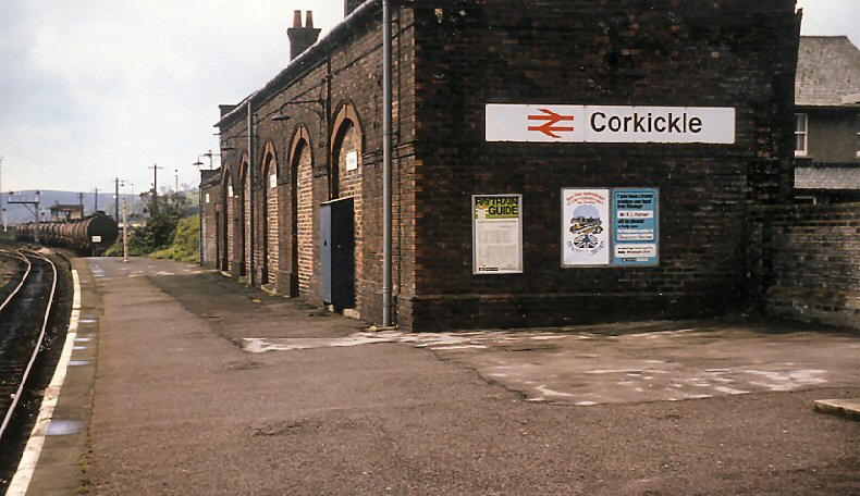
The single platform station has kept its main building, but this is now in private residential use. Shelters and train information boards are sited near the main entrance, which has step-free access from the approach road.[3] There are timetable posters and a telephone to provide train running information.
Service
Monday to Saturdays there is an irregular service (hourly for parts of the day, less frequent at other times) northbound to Carlisle and southbound to Barrow-in-Furness. There are no trains after 20.00 on Mondays-Saturdays and no Sunday service.[4]
The Corkickle Brake
In 1881 the Corkickle Brake, an inclined wagonway 525 yards (480 m) in length and with gradients of between 1 in 5.2 and 1 in 6.6 was built from the Furness Railway main line, a short distance to the south of Corkickle station, to the Earl of Lonsdale's Croft Pit.[5] The 'brake' closed in 1931 due to the worsening financial situation of the colliery's owners, Lonsdale's Whitehaven Colliery Co.[5] In May 1955, the incline was re-opened, this time to serve the factory of Marchon Products - a subsidiary of Albright and Wilson - at Kells. It was used mainly to haul rail tanker wagons containing sulphuric acid from the main line - by now in the ownership of British Railways - to the Marchon factory. The Corkickle Brake closed for good on 31 October 1986 and the task of transporting the acid and other chemicals was taken over by road tankers.[6]
Freight
The area immediately south of the station was for many years a busy freight location, handling haematite ore traffic from Moor Row mine as well as the aforementioned chemical tankers up & down the incline at the nearby Preston Street goods depot (the one time W&FJR passenger terminus) and associated yard.[7] Two signal boxes (Corkickle No. 1 & No. 2)[8][9] supervised the sidings, as well as controlling access to and from the incline and the Moor Row branch (the surviving portion of the former Whitehaven, Cleator and Egremont Railway line to Egremont & Sellafield). Although sufficiently busy to require its own resident shunting locomotive well into the 1970s, the gradual loss of traffic from the early 1980s onwards saw facilities run down and following the demise of Preston Street depot, the yard eventually closed (along with both signal boxes, which had been replaced by standard LMR-designed structures in 1958-59)[10] on 15/16 February 1997.[11] Today no trace remains of the sidings or either signal box, only the one surviving running line southwards towards St Bees & Sellafield.
Notes
- 1 2 Quick 2009, p. 410.
- ↑ British Railways (1957/8)
- ↑ Corkickle station facilities National Rail Enquiries; Retrieved 2 December 2016
- ↑ GB Rail Timetable (May 2016), Table 100
- 1 2 Quayle (2006), p.60
- ↑ Quayle (2006), p.61-65
- ↑ Class 25s - Around BarrowDerby Sulzers, Retrieved 2013-10-03
- ↑ D. Allen and C.J. Woolstenholmes, A Pictorial Survey of London Midland Signalling, OPC, 1996, p. 123. ISBN 0-86093-523-X
- ↑ British Railways Layout Plans of the 1950s, Vol.6 West Coast Main Line (Euxton Junction to Mossband) and branches.Signalling Record Society 1993, p.44. ISBN 1-873228-05-8.
- ↑ Quayle (2006), p.85.
- ↑ Quayle (2006), p.93.
References
- British Railways London Midland Region Passenger Timetable, 16 September 1957 to 8 June 1958.
- GB Rail Timetable Winter Edition 13 December 2009 - 22 May 2010.
- Hyde, M. and Pevsner, N The Buildings of England: Cumbria. Yale University Press 2010. ISBN 978-0-300-12663-1
- Joy, D. Cumbrian Coast Railways. Dalesman Publishing 1968.
- Joy, D. A Regional History of the Railways of Great Britain, Volume 14: The Lake Counties. David and Charles 1983. ISBN 0-946537-02-X
- Mountford, C.E. Rope and Chain Haulage - The Forgotten Element of Railway History. Industrial Railway Society, 2013. ISBN 9781901556841
- Quayle, H. Whitehaven - The Railways and Waggonways of a Unique Cumberland Port. Cumbrian Railways Association 2006. ISBN 978-0-9540232-5-6
- Quick, Michael (2009) [2001]. Railway passenger stations in Great Britain: a chronology (4th ed.). Oxford: Railway and Canal Historical Society. ISBN 978-0-901461-57-5. OCLC 612226077.
- Routledge, A.W. Marchon - The Whtehaven Chemical Works. Tempus, 2005. ISBN 0752435728
External links
| Wikimedia Commons has media related to Corkickle railway station. |
- Train times and station information for Corkickle railway station from National Rail
- History and pictures of the Corkickle Brake
- View south from the station in 1986
| Preceding station | Following station | |||
|---|---|---|---|---|
| Northern Cumbrian Coast Line Mondays-Saturdays only |
Coordinates: 54°32′31″N 3°34′55″W / 54.542°N 3.582°W