College of Medicine of Maryland
|
College of Medicine of Maryland | |
|
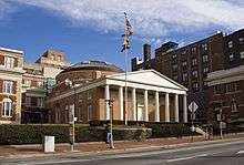
Davidge Hall in 2011 | |
   | |
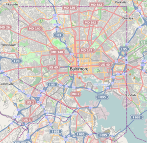
| Location | 522 West Lombard Street, at northeast corner with South Greene Street, Baltimore, Maryland |
|---|---|
| Coordinates | 39°17′13″N 76°37′25″W / 39.28694°N 76.62361°WCoordinates: 39°17′13″N 76°37′25″W / 39.28694°N 76.62361°W |
| Built | 1812 |
| Architect | Long, Robert Cary, Sr. |
| Architectural style | Greek Revival |
| NRHP Reference # | 97001275 |
| Significant dates | |
| Added to NRHP | September 25, 1997[1] |
| Designated NHL | September 25, 1977[2] |
The College of Medicine of Maryland, or also known since 1959 as Davidge Hall, has been in continuous use for medical education since 1813, the oldest such structure in the United States.[3] A wide pediment stands in front of a low, domed drum structure, which housed the anatomical theater. A circular chemistry hall was housed on the lower level under the anatomical theater.[4]
The dome is a Delormé structure, with small slats forming the dome. The design, originated by Philibert de l'Orme, was also used at Jefferson's Monticello. Somewhat inspired by the ancient Pantheon in Rome. The supervising architect was Robert Cary Long, Sr., a famous local father-son team of architects who also designed many other famous buildings in the city. The front portico facing West Lombard Street (formerly King George Street) is of wood construction with Doric columns. To the west is South Greene Street (named for Revolutionary War Gen. Nathanael Greene, (1742-1786), and aide to Gen. George Washington of the Continental Army)[5]
.jpg)
Davidge Hall was named for the founder and first dean of the College of Medicine of Maryland, Dr. John Beale Davidge. The College of Medicine is the oldest public and fifth oldest medical school in the United States. Dr. Davidge, along with James Cocke and John Shaw, offered medical instruction in a small theater beginning in late 1807. In November of that year, a mob broke into Davidge's small domed theater, took the cadaver and dragged it through the streets. In December, the Maryland General Assembly passed a bill establishing a college of medicine. A lot was obtained for construction of a building in 1811. Evidence exists that in addition to Robert Cary Long, Jr., early design work may have also been performed by French émigré architect J. Maximilian M. Godefroy, son-in-law of Dr. Crawford (who also did work on the Battle Monument during 1815-1827, in Baltimore's former Courthouse Square at North Calvert, between East Lexington and Fayette Streets and the First Independent Church of Baltimore (later First Unitarian Church of Baltimore (Unitarian and Universalist) at West Franklin and North Charles Streets in 1817, both of which still stand. Work began in 1812 and was completed the following year.[5]
The use of the name "Davidge Hall" did not appear until about 1959, when a previous UMAB campus building of the same name was demolished.
Davidge Hall was listed on the National Register of Historic Places on September 25, 1977 and made a National Historic Landmark on September 25, 1997.[1] Davidge Hall is also considered the oldest building in continuous use for medical education in the Northern Hemisphere. It is included within the Baltimore City National Heritage Area.[6]
References
- 1 2 National Park Service (2008-04-15). "National Register Information System". National Register of Historic Places. National Park Service.
- ↑ "College of Medicine of Maryland". National Historic Landmark summary listing. National Park Service. Retrieved 2008-06-16.
- ↑ "Maryland Historical Trust". National Register of Historic Places: Properties in Baltimore City. Maryland Historical Trust. 2008-06-10.
- ↑ Dorsey, John; Dilts, James D. (1981). A Guide to Baltimore Architecture (Second ed.). Centreville, Maryland: Tidewater Publishes. pp. 102–103. ISBN 0-87033-272-4.
- 1 2 John G. Waite Associates (December 5, 1997). "National Register of Historic Places Inventory-Nomination: College of Medicine of Maryland" (pdf). National Park Service.
- ↑ "Baltimore National Heritage Area Map" (PDF). City of Baltimore. Retrieved March 11, 2012.
External links
 Media related to Davidge Hall at Wikimedia Commons
- Davidge Hall, University of Maryland, Baltimore City, including photo in 1979, at Maryland Historical Trust
- Historic American Buildings Survey (HABS) No. MD-304, "University of Maryland, Medical Building, Greene & Lombard Streets, Baltimore, Independent City, MD", 11 measured drawings, supplemental material
- Explore Baltimore Heritage - Davidge Hall


