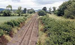
Clunes railway station, Scotland
| Clunes | |
|---|---|
|
View towards the site of the station, 1986 | |
| Location | |
| Place | Near Kirkhill |
| Area | Highland |
| Coordinates | 57°29′02″N 4°24′22″W / 57.484°N 4.406°WCoordinates: 57°29′02″N 4°24′22″W / 57.484°N 4.406°W |
| Grid reference | NH558463 |
| Operations | |
| Original company | Inverness and Ross-shire Railway |
| Pre-grouping | Highland Railway |
| Post-grouping | London, Midland and Scottish Railway |
| Platforms | 2 |
| History | |
| 1864 | Station opened |
| 13 June 1960 | Closed to passengers |
| 27 January 1964 | Closed to goods |
| Disused railway stations in the United Kingdom | |
|
Closed railway stations in Britain A B C D–F G H–J K–L M–O P–R S T–V W–Z | |
|
| |
Clunes railway station was a railway station on the Inverness and Ross-shire Railway, on the Inverness to Dingwall section. It was situated to the north of the village of Kirkhill.
The line became part of the Highland Railway on 1 February 1865, then, at grouping in 1923, it became part of the London Midland and Scottish Railway.
A passing loop was opened at Clunes in 1904. In 1914, this became the end of a 6 mile long double track section from Clachnaharry. This section reverted to single track in 1966.
| Preceding station | Historical railways | Following station | ||
|---|---|---|---|---|
| Lentran Line open; Station closed |
Inverness and Ross-shire Railway Highland Railway |
Beauly Line and station open | ||
References
- Vallance, H.A.; Clinker, C.R.; Lambert, Anthony J. (1985). The Highland Railway: The History of the Railways of the Scottish Highlands. Vol 2 (4th ed.). David St John Thomas. ISBN 0946537232.
- Ordnance Survey, 1:25,000 map NH54, 1961
This article is issued from Wikipedia - version of the 4/15/2016. The text is available under the Creative Commons Attribution/Share Alike but additional terms may apply for the media files.
