Cipayung
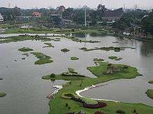
Cipayung is a subdistrict (kecamatan) of East Jakarta, Indonesia. The boundaries of Cipayung are Pondok Gede Raya Road to the North, Sunter River to the East, and Jagorawi Tollway to the West. The Subdistrict is located in the outskirts of Jakarta. Marshes can still be found in Cipayung.
Several recreation places such as Taman Mini Indonesia Indah, Cibubur scouting complex, and the PKI Betrayal Museum is located in Cipayung Subdistrict.
Kelurahan (administrative villages)
Cipayung is divided into eight kelurahan or "administrative villages":
- Lubang Buaya - area code 13810
- Ceger - area code 13820
- Cipayung - area code 13840
- Munjul - area code 13850
- Pondok Ranggon - area code 13860
- Cilangkap - area code 13870
- Setu - area code 13880
- Bambu Apus - area code 13890
List of important places

- Arboretum botanical forest
- Museum Pengkhianatan PKI ("PKI Betrayal Museum")
- Pancasila Sakti or Pahlawan Revolusi (Indonesian "Revolution Heroes") Monument
- Scout's camping ground and recreation area (Bumi Perkemahan dan Graha Wisata Pramuka)
- Taman Mini Indonesia Indah
- Indonesian National Badminton Team Headquarters
- Bambu Apus market
- Defunct Tanjung Barat-Jatiasih railway line, The railway line is now closed after it opened a new path past the Tambun in the early decades of the 2000s. Now, the former rail line is dirty and flattened into a tollroad and several railway stations and bus stops unloaded because Jakarta Outer Ring Road section TMII-Cikunir in 2006 is project. Formerly, line this served by pasengger and frieght train while passing old lines.
Pondok Ranggon Flood Control Lakes
In March 2014, three flood control lakes are being built and predicted will be operated before end of the year. Pondok Ranggon Lake I is 11.5 hectares, Pondok Ranggon Lake II is 5 hectares and Pondok Ranggon Lake III is 2 hectares with total capacity of 550,000 cubic squares. The lakes and surrounding area will be used as recreational area with garden and pathway.[1]
References
- ↑ "DKI Bangun Tiga Waduk di Pondok Rangon". March 7, 2014.
Coordinates: 6°19′S 106°54′E / 6.317°S 106.900°E