Chopda
| Chopda चोपडा | |
|---|---|
| city | |
 Chopda Location in india | |
| Coordinates: 21°15′N 75°18′E / 21.25°N 75.3°ECoordinates: 21°15′N 75°18′E / 21.25°N 75.3°E | |
| Country |
|
| State | Maharashtra |
| District | Jalgaon |
| Elevation | 190 m (620 ft) |
| Population (2011) | |
| • Total | 71,863 |
| Languages | |
| • Official | india |
| Time zone | IST (UTC+5:30) |
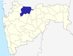
Chopda is a city and a municipal council in Jalgaon district in the state of Maharashtra, India.
Geography
Chopda is located at 21°15′N 75°11′E / 21.25°N 75.18°E[1] and has an average elevation of 190 metres (623 feet).
Chopda is a town in the Jalgaon district in Maharashtra, a state in the western region of India. The town is situated on the banks of the Ratnavati River and is linked by road to the rest of Jalgaon district and to Yaval, Amalner and Jalgaon. Chopda is strategically located as one of the major stations on the Maharashtra-Madhya Pradesh trading route. State Highway No. 4, Burhanpur-Ankleshwar goes through Chopda. The Tapi River, one of the major rivers in India, is approximately 10 km from Chopda.
Schools and colleges

.jpg)
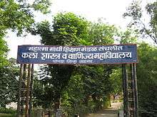
Chopda is well known in the region for its academic institutes and colleges. It hosts a wide range of colleges and institutes with good reputation in the arts and sciences. Schools include Pratap Vidya Mandir, Kasturba,Clara school, Vidyalaya, Vivekanada Vidyalaya, Pankaj Global School, Madhyamik Kanya Vidyalaya, College include Arts, Science and Commerce College,Chopda, College of Pharmacy, Smt. S.S.Patil Polytechnic, Pankaj Mahavidyalaya, PVM B.Ed. College etc. Various other academic institutes and private coaching classes are run in the city. Institutes like Amar Sanstha are into coaching in various fields. Pankaj Global Public School is first CBSE grant school un whole Chopda. School have lots of high quality staff and all other necessary thing it is best CBSE school in Chopda, Jalgaon,Maharashtra, India. Shastri House Sports Captain:-Mr.Maitray Wani.
Demographics
Chopda has a population of 271863 (According to http://www.geohive.com/cntry/in-27.aspx ). Males constitute 52% of the population and females 48%. The average literacy rate is 67%, higher than the national average of 59.5%; with male literacy at 74% and female literacy at 59%. Around 13% of the population is under six years of age. Languages and dialects spoken include Ahirani, Gujari, Khandeshi, Marathi, Urdu, Gujarati, Marwari, Pawara.barela, Bhilau, Hindi, and English.
Transport
The main airport is at Jalgaon. Railway stations include CR Dharangaon, CR Amalner, CR Jalgaon, and CR Bhusaval. Chopda is connected to the road by neighboring cities like Jalgaon(60 km),Amalner(36 km), Yawal(45 km), Shirpur (45 km) etc.
Temples
City has several ancient temples like Hareshwar,Ram Mandir,Jabare Ram Mandir,Shani Mandir,Krishna Mandir etc
Economy
Chopda has an agriculture based economy. Major crops include sugar cane, cotton, bananas and pulses; and sugar, cotton and poultry are processed in the city. It also has several educational institutes and serves as a regional transportation center. City has other businesses like Gold, cloth markets mainly on MG road.
Tourist places
.jpg)

Local tourist sites include the hot springs at Unapdev. According to mythology, it was generated by Lord Rama's arrow to create hot springs which are of medicinal properties to cure skin disease of a sage and is therefore considered a holy site. There are picnic spots around Unapdev. Some other attractions include Chaugaon fort (or Gavali Fort) near Lasur, Nageshwar temple some scenic Satpuda hills and various spots on river Tapti. Rel Maruti Mandir is a temple of Lord Hanuman located 8 km from Chopda on the route to dharangaon. Aner Dam is also a tourist site which is 20 km from he city. It is an old dam created on river Aner.
Municipal corporation
The Municipal Council for Chopda was established in 1870.
- Presidents of the Municipal Corporation
| Name of Councilors | From Date | To Date | |
|---|---|---|---|
| Tahasildar | 1916 | 1918 | |
| Shri. Aanandrao Shripatrao Deshmukh | 1918 | 31-12-1928 | |
| Shri. Maganlal Nagindas Gujrathi | 1-1-1929 | 9-6-1941 | |
| Shri. Fakirchand Jankiram Agrawal | 10-6-1941 | 6-10-1944 | |
| Shri. Maganlal Nagindas Gujrathi | 7-10-1944 | 9-10-1946 | |
| Shri. Dattatrya Balvant Tillu | 10-10-1946 | 13-10-1947 | |
| Shri. Maganlal Nagindas Gujrathi | 14-10-1947 | 1960 | |
| Shri. Raghunath Sandu Patil | 1960–1961 | 1963–1964 | |
| Shri. Ranchoddas Nagindas Gujrathi | 1964-65 | 1-7-1967 | |
| Shri. Sitaram Narayan Agrawal | 2-7-1967 | 29-7-1971 | |
| Shri. Ranchoddas Nagindas Gujrathi | 30-7-1971 | 3-7-1975 | |
| Shri. Arunlal Goverdhandas Gujarathi | 4-7-1975 | 5-2-1981 | |
| Administrator | 6-2-1981 | 30-4-1985 | |
| Dr.Sau.Susheelaben Shah | 21-5-1985 | 16-12-1991 | |
| Shri. Ramanlal Babulal Gujarathi | 17-12-1991 | 17-12-1996 | |
| Dr.Sau.Susheelaben Shah | 18-12-1996 | 16-12-2001 | |
| Sau. Malubai Digamber Patil | 18-12-2001 | 22-12-2006 | |
| Sau.Tarabai Diliprao Patil | 26-12-2006 | 26-10-2007 | |
| Dr.Jaya Diliprao Patil | 27-10-2007 | 09-06-2009 | |
| Sau.Kalpana Vilas Jagtap | 10-6-2009 | 26-10.2011 | |
| Shri. Adv.Sandeep Suresh Patil | 26-12-2011 | 30-06-2014 |
Notable politicians
- Members of Legislative Assembly
Chandrakant Baliram Sonawane (Shiv Sena) 2014-till now
Maitray Wani
Jagdish Valvi (NCP) 2009–2014
Kailash Patil (Shivsena) 2004–2009
Arun Gujarathi (NCP) 1999–2004 (Speaker of Maharashtra Legislative Assembly)
Arunbhai Gujarathi (INC) 1994–1999
Arun Gujarathi (Samajwadi Congress) 1985–1990
Sharchchandrika Suresh Patil (Indian National Congress)1981–1982
Education Ministress, Maharashtra.
- Members of Parliament
Rakshatai Khadse(BJP) 2014-till now
Haribhau Javle (BJP) 2009–2014
Vasantaray Jeevanarav More (National Congress Party) 2007–2009
Annasaheb M.K. Patil (BJP) 2003–2007
Annasaheb M.K. Patil (BJP) 1999–2003
Annasaheb M.K. Patil (BJP) 1998–1999
Annasaheb M.K. Patil (BJP) 1996–1998
Vijay Naval Patil (INC) 1991–1996
Uttam Laxmanrao Patil (BJP) 1989–1991
Vijay Naval Patil (INC) 1984–1989
Vijay Naval Patil (INC(I)) 1980–1984
Sonusing Dhansing Patil (BLD)
- Jagannath Damu Patil (NCP)
Chairman-Krushi Utpanna Bazar Samiti Chopda (from 2015)
References
External links
- Chopda Municipal Corporation Website
- Chopda Education Society's B.Ed. College
- Mahatma Gandhi Shikshan Mandal's Smt. Sharadchandrika Suresh Patil College of Pharmacy Chopda
- Mahatma Gandhi Shikshan Mandal's Art, Science & Commerce College, Chopda.
- Manudevi Temple
- The Chopda Peoples Co.op. Bank Ltd.
