Chara (rural locality)
For other uses, see Chara.
| Chara (English) Чара (Russian) | |
|---|---|
|
- Rural locality[1] - Selo[1] | |
|
| |
.svg.png) Location of Zabaykalsky Krai in Russia | |
 Chara | |
|
| |
| Administrative status | |
| Country | Russia |
| Federal subject | Zabaykalsky Krai[1] |
| Administrative district | Kalarsky District[1] |
| Administrative center of | Kalarsky District[1] |
| Statistics | |
| Population (2010 Census) | 1,903 inhabitants[1] |
| Time zone | YAKT (UTC+09:00)[2] |
Chara (Russian: Чара) is a rural locality (a selo) and the administrative center of Kalarsky District of Zabaykalsky Krai, Russia, located on the Chara River at an elevation of 710 meters (2,330 ft) above sea level. Population:1,903 (2010 Census);[1] 2,063 (2002 Census);[3] 3,441 (1989 Census).[4]
Geography

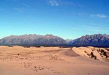
The Chara Sands, a "desert" in the middle of Siberia, as seen near Novaya Chara. The Kodar Mountains lie in the background.
The Chara Sands, a 34 square kilometers (13 sq mi) area of active sand dunes, lies 5 kilometers (3.1 mi) southwest of Chara.
Climate
Chara has a subarctic climate (Köppen climate classification Dwc), with long, bitterly cold winters and warm, mild summers. Precipitation is quite low but is much higher in summer than at other times of the year.
| Climate data for Chara | |||||||||||||
|---|---|---|---|---|---|---|---|---|---|---|---|---|---|
| Month | Jan | Feb | Mar | Apr | May | Jun | Jul | Aug | Sep | Oct | Nov | Dec | Year |
| Record high °C (°F) | −3.2 (26.2) |
4.2 (39.6) |
10.0 (50) |
19.1 (66.4) |
28.2 (82.8) |
35.0 (95) |
34.5 (94.1) |
33.8 (92.8) |
27.4 (81.3) |
19.3 (66.7) |
7.5 (45.5) |
0.6 (33.1) |
35 (95) |
| Average high °C (°F) | −25.4 (−13.7) |
−17.3 (0.9) |
−7.3 (18.9) |
2.9 (37.2) |
12.0 (53.6) |
20.9 (69.6) |
23.5 (74.3) |
20.6 (69.1) |
11.7 (53.1) |
0.6 (33.1) |
−14.0 (6.8) |
−24.6 (−12.3) |
0.3 (32.55) |
| Daily mean °C (°F) | −32.4 (−26.3) |
−27.2 (−17) |
−16.9 (1.6) |
−3.7 (25.3) |
5.6 (42.1) |
13.7 (56.7) |
16.5 (61.7) |
13.5 (56.3) |
5.2 (41.4) |
−5.8 (21.6) |
−20.9 (−5.6) |
−30.4 (−22.7) |
−6.9 (19.59) |
| Average low °C (°F) | −38.0 (−36.4) |
−35.5 (−31.9) |
−27.0 (−16.6) |
−11.0 (12.2) |
−1.1 (30) |
6.4 (43.5) |
9.6 (49.3) |
6.9 (44.4) |
−0.5 (31.1) |
−11.4 (11.5) |
−26.5 (−15.7) |
−35.3 (−31.5) |
−13.62 (7.49) |
| Record low °C (°F) | −54.4 (−65.9) |
−56.2 (−69.2) |
−48.7 (−55.7) |
−36.8 (−34.2) |
−18.7 (−1.7) |
−6.2 (20.8) |
−2.5 (27.5) |
−5.3 (22.5) |
−17.9 (−0.2) |
−35.5 (−31.9) |
−47.5 (−53.5) |
−53.8 (−64.8) |
−56.2 (−69.2) |
| Average precipitation mm (inches) | 3 (0.12) |
3 (0.12) |
3 (0.12) |
14 (0.55) |
43 (1.69) |
70 (2.76) |
76 (2.99) |
84 (3.31) |
48 (1.89) |
15 (0.59) |
7 (0.28) |
4 (0.16) |
370 (14.58) |
| Average relative humidity (%) | 78 | 72 | 66 | 59 | 58 | 65 | 71 | 75 | 72 | 72 | 77 | 79 | 70.3 |
| Mean monthly sunshine hours | 78 | 144 | 208 | 231 | 245 | 249 | 248 | 214 | 162 | 149 | 99 | 59 | 2,086 |
| Source #1: Pogoda.ru.net[5] | |||||||||||||
| Source #2: HKO | |||||||||||||
Transportation
It is served by the Chara Airport.[6]
References
- 1 2 3 4 5 6 7 Russian Federal State Statistics Service (2011). "Всероссийская перепись населения 2010 года. Том 1" [2010 All-Russian Population Census, vol. 1]. Всероссийская перепись населения 2010 года (2010 All-Russia Population Census) (in Russian). Federal State Statistics Service. Retrieved June 29, 2012.
- ↑ Правительство Российской Федерации. Федеральный закон №107-ФЗ от 3 июня 2011 г. «Об исчислении времени», в ред. Федерального закона №271-ФЗ от 03 июля 2016 г. «О внесении изменений в Федеральный закон "Об исчислении времени"». Вступил в силу по истечении шестидесяти дней после дня официального опубликования (6 августа 2011 г.). Опубликован: "Российская газета", №120, 6 июня 2011 г. (Government of the Russian Federation. Federal Law #107-FZ of June 31, 2011 On Calculating Time, as amended by the Federal Law #271-FZ of July 03, 2016 On Amending Federal Law "On Calculating Time". Effective as of after sixty days following the day of the official publication.).
- ↑ Russian Federal State Statistics Service (May 21, 2004). "Численность населения России, субъектов Российской Федерации в составе федеральных округов, районов, городских поселений, сельских населённых пунктов – районных центров и сельских населённых пунктов с населением 3 тысячи и более человек" [Population of Russia, Its Federal Districts, Federal Subjects, Districts, Urban Localities, Rural Localities—Administrative Centers, and Rural Localities with Population of Over 3,000] (XLS). Всероссийская перепись населения 2002 года [All-Russia Population Census of 2002] (in Russian). Retrieved August 9, 2014.
- ↑ Demoscope Weekly (1989). "Всесоюзная перепись населения 1989 г. Численность наличного населения союзных и автономных республик, автономных областей и округов, краёв, областей, районов, городских поселений и сёл-райцентров" [All Union Population Census of 1989: Present Population of Union and Autonomous Republics, Autonomous Oblasts and Okrugs, Krais, Oblasts, Districts, Urban Settlements, and Villages Serving as District Administrative Centers]. Всесоюзная перепись населения 1989 года [All-Union Population Census of 1989] (in Russian). Институт демографии Национального исследовательского университета: Высшая школа экономики [Institute of Demography at the National Research University: Higher School of Economics]. Retrieved August 9, 2014.
- ↑ "Pogoda.ru.net-Climate Data for Chara 1981-2010" (in Russian). Retrieved April 26, 2012.
- ↑ "Chara Airport". OurAirports. Retrieved April 16, 2013.
This article is issued from Wikipedia - version of the 1/26/2016. The text is available under the Creative Commons Attribution/Share Alike but additional terms may apply for the media files.