Williamston, South Carolina
| Williamston, South Carolina | |
|---|---|
| Town | |
|
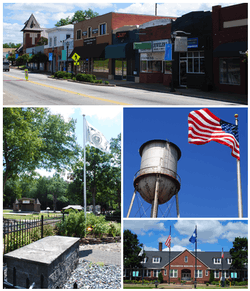
Top, left to right: Downtown Williamston, the grave of West Allen William (founder of Williamston) in Williamston Springs Mineral Park, water tower at the Williamston Mill, Williamston Municipal Center | |
|
Location of Williamston, South Carolina | |
| Coordinates: 34°37′4″N 82°28′45″W / 34.61778°N 82.47917°WCoordinates: 34°37′4″N 82°28′45″W / 34.61778°N 82.47917°W | |
| Country | United States |
| State | South Carolina |
| County | Anderson |
| Area | |
| • Total | 3.7 sq mi (9.5 km2) |
| • Land | 3.6 sq mi (9.4 km2) |
| • Water | 0.04 sq mi (0.1 km2) |
| Elevation | 814 ft (248 m) |
| Population (2010) | |
| • Total | 3,934 |
| • Density | 1,080/sq mi (417.1/km2) |
| Time zone | Eastern (EST) (UTC-5) |
| • Summer (DST) | EDT (UTC-4) |
| ZIP code | 29697 |
| Area code(s) | 864 |
| FIPS code | 45-77875[1] |
| GNIS feature ID | 1251452[2] |
| Website |
www |
Williamston is a town in Anderson County, South Carolina, United States, The population was 3,934 at the 2010 census.[3]
Geography
Williamston is located in northeastern Anderson County at 34°37′4″N 82°28′45″W / 34.61778°N 82.47917°W (34.617699, -82.479256).[4] The twin towns of Pelzer and West Pelzer are 2 miles (3 km) to the north. Anderson, the county seat, is 15 miles (24 km) to the southwest.
According to the United States Census Bureau, the town has a total area of 3.7 square miles (9.5 km2), of which 3.6 square miles (9.4 km2) is land and 0.04 square miles (0.1 km2), or 1.01%, is water.[3]
Demographics
| Historical population | |||
|---|---|---|---|
| Census | Pop. | %± | |
| 1890 | 935 | — | |
| 1900 | 991 | 6.0% | |
| 1910 | 1,957 | 97.5% | |
| 1920 | 2,322 | 18.7% | |
| 1930 | 2,235 | −3.7% | |
| 1940 | 2,509 | 12.3% | |
| 1950 | 2,782 | 10.9% | |
| 1960 | 3,721 | 33.8% | |
| 1970 | 3,991 | 7.3% | |
| 1980 | 4,310 | 8.0% | |
| 1990 | 3,876 | −10.1% | |
| 2000 | 3,791 | −2.2% | |
| 2010 | 3,934 | 3.8% | |
| Est. 2015 | 4,124 | [5] | 4.8% |
As of the census[1] of 2000, there were 3,791 people, 1,590 households, and 1,090 families residing in the town. The population density was 1,056.2 people per square mile (407.7/km²). There were 1,762 housing units at an average density of 490.9 per square mile (189.5/km²). The racial makeup of the town was 80.80% White, 17.67% African American, 0.08% Native American, 0.11% Asian, 0.66% from other races, and 0.69% from two or more races. Hispanic or Latino of any race were 1.74% of the population.
There were 1,590 households out of which 27.6% had children under the age of 18 living with them, 49.9% were married couples living together, 14.0% had a female householder with no husband present, and 31.4% were non-families. 28.8% of all households were made up of individuals and 14.7% had someone living alone who was 65 years of age or older. The average household size was 2.38 and the average family size was 2.91.
In the town the population was spread out with 22.8% under the age of 18, 7.4% from 18 to 24, 28.3% from 25 to 44, 22.7% from 45 to 64, and 18.9% who were 65 years of age or older. The median age was 40 years. For every 100 females there were 91.7 males. For every 100 females age 18 and over, there were 86.7 males.
The median income for a household in the town was $31,458, and the median income for a family was $37,679. Males had a median income of $30,585 versus $21,771 for females. The per capita income for the town was $14,085. About 9.4% of families and 12.3% of the population were below the poverty line, including 10.3% of those under age 18 and 13.3% of those age 65 or over.
History

The founding of Williamston was a dream come true for West Allen Williams. One day in 1842 this farmer stopped for a nap while riding over his property. He dreamed of a clear spring with healing qualities and envisioned pale and feeble people improving miraculously. Upon awakening, he followed a trickling sound and discovered the source of the Williamston mineral spring.
As news of the medicinal water spread, the town grew and became a major resort when the railroads arrived in 1851. Soon it became known as the "Saratoga of the South", which was a referral to a similar spring in New York. To accommodate the influx, the Mammoth Hotel was built near the spring and was the largest building in the state at that time, featuring 150 rooms plus bowling alleys and ballrooms. Unfortunately, a devastating fire in 1860 destroyed it and other buildings. The town was initially known as Mineral Springs, but this was changed to Williamston in 1852. Mr. Williams set aside property to preserve the spring and to begin schools and churches.
The Civil War brought an end to that "golden era", but not without leaving its own history. The last skirmish east of the Mississippi took place a few miles north of town when cadets from the Arsenal Academy of Columbia encountered Stoneman's Raiders on May 1, 1865.
In 1871, Dr. Samuel Lander established a girls' school which eventually moved to the city of Greenwood and became Lander University. Dr. Lander was instrumental in prohibiting the sale of liquor in town, a feeling which exists today in this community served by more than 70 churches.
Around the turn of the century the cotton mills settled near the river and played major roles in shaping the communities. Many families still treasure memories of events sponsored by the mills and of teams playing in the old textile leagues. Shoeless Joe Jackson took his first steps on Pelzer's mill hill and went on to become the greatest natural baseball player ever.
Railroads continued to serve the area until the 1950s. The P & N was designed to operate through the heart of the Piedmont textile industry and is remembered by its motto "A Mill to the Mile" and by its rate of a penny a mile. With today's dominance of auto transportation, Williamston has highways 8, 20, and 29 connecting it to upstate corridors including nearby Interstate 85.
Education
Public schools in the Pelzer/Williamston/West Pelzer area are part of Anderson District One. The public elementary schools in Anderson district one are Cedar Grove Elementary, Powdersville Elementary, Concrete Primary, Spearman Elementary, Hunt Meadows Elementary, West Pelzer Elementary, Palmetto Elementary, and Wren Elementary. The Middle schools are Palmetto Middle, Wren Middle, and Powdersville Middle. High schools are; Palmetto High School, Palmetto High Freshman Academy, Powdersville High School, Wren High School, and Wren High School Freshman Academy.[7]
References
- 1 2 "American FactFinder". United States Census Bureau. Retrieved 2008-01-31.
- ↑ "US Board on Geographic Names". United States Geological Survey. 2007-10-25. Retrieved 2008-01-31.
- 1 2 "Geographic Identifiers: 2010 Demographic Profile Data (G001): Williamston town, South Carolina". U.S. Census Bureau, American Factfinder. Retrieved August 8, 2013.
- ↑ "US Gazetteer files: 2010, 2000, and 1990". United States Census Bureau. 2011-02-12. Retrieved 2011-04-23.
- ↑ "Annual Estimates of the Resident Population for Incorporated Places: April 1, 2010 to July 1, 2015". Retrieved July 2, 2016.
- ↑ "Census of Population and Housing". Census.gov. Retrieved June 4, 2015.
- ↑ http://www.anderson1.k12.sc.us/domain/11
External links
- Town of Williamston official website
- The Journal, Williamston's newspaper
- PelzerWilliamston.com, local information
- Anderson School District One

