Cavenham
| Cavenham | |
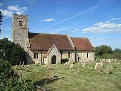
 St Andrew's Church, Cavenham |
|
 Cavenham |
|
| Population | 136 (2011 census) |
|---|---|
| OS grid reference | TL7669 |
| District | Forest Heath |
| Shire county | Suffolk |
| Region | East |
| Country | England |
| Sovereign state | United Kingdom |
| Police | Suffolk |
| Fire | Suffolk |
| Ambulance | East of England |
| EU Parliament | East of England |
Coordinates: 52°17′48″N 0°35′02″E / 52.2968°N 00.5839°E
Cavenham is a civil parish in Suffolk, England, 10 kilometres (6 mi) northwest of Bury St Edmunds. It is in the local government district of Forest Heath, and the electoral ward of Icini.[1] At the 2001 UK census, Cavenham Parish had a population of 127.[2] In the 1870s it had a population of 229.[3]
The parish includes Cavenham Heath, a Site of Special Scientific Interest (SSSI) with a sand and gravel quarry close to it[4] and is the location of the Black Ditches, an Anglo-Saxon boundary ditch which is believed to be the most easterly of a series of early Anglo-Saxon defensive earthworks built across the Icknield Way. Part of this also forms an SSSI to the south-east of the village.
References
| Wikimedia Commons has media related to Cavenham parish, Suffolk. |
- ↑ "Ward: Icini" (PDF). Forest Heath District Council. Retrieved 2008-05-25.
- ↑ "Cavenham CP". Neighbourhood Statistics. Retrieved 2008-05-25.
- ↑ "Cavenham Through Time". Retrieved 2011-01-21.
- ↑ "Planning Applications – R03/214". Suffolk County Council. 2003-11-04. Retrieved 2008-05-25.
This article is issued from Wikipedia - version of the 1/24/2016. The text is available under the Creative Commons Attribution/Share Alike but additional terms may apply for the media files.