Kostrzyn nad Odrą
| Kostrzyn nad Odrą | |||
|---|---|---|---|
|
| |||
| |||
 Kostrzyn nad Odrą | |||
| Coordinates: 52°35′18″N 14°40′0″E / 52.58833°N 14.66667°E | |||
| Country |
| ||
| Voivodeship | Lubusz | ||
| County | Gorzów | ||
| Gmina | Kostrzyn nad Odrą (urban gmina) | ||
| Established | 13th century | ||
| Town rights | 1300 | ||
| Government | |||
| • Mayor | Andrzej Kunt | ||
| Area | |||
| • Total | 46.17 km2 (17.83 sq mi) | ||
| Population (2007) | |||
| • Total | 19,952 | ||
| • Density | 430/km2 (1,100/sq mi) | ||
| Time zone | CET (UTC+1) | ||
| • Summer (DST) | CEST (UTC+2) | ||
| Postal code | 66-470 | ||
| Area code(s) | +48 95 | ||
| Car plates | FGW | ||
| Climate | Cfb | ||
| Website | Official website | ||
Kostrzyn nad Odrą /ˈkɒst.ʃɪn næd ˈɒdrəm/ (Polish pronunciation: [ˈkɔst.ʂɨn ˌnad ˈɔdrɔ̃]; German: Küstrin [kʏsˈtʁiːn]) is a town in western Poland at the confluence of the Oder and Warta rivers, on the border with Germany. Located in Lubusz Voivodeship in Gorzów County, it had 19,952 inhabitants as of 2007.
History
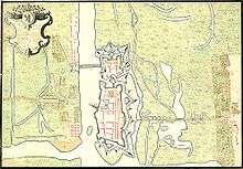
From about 960 to 1200 most of the territory, along with its castle, was held by the dukes of Poland. Duke Mieszko I of Poland used Kostrzyn's strategic location as a staging area during his expedition to Cedynia (battle of Zehden). Bolesław I the Brave also prepared here for conquests and battles in Bautzen.[1]
The name of the town was first mentioned in 1232 in a Polish letter to the Teutonic Knights, in which the old Slavic name Cozsterine (hence the later name Küstrin) was mentioned. In the 12th century it developed into a fortified outpost and a Polish taxation post. In 1223 Prince Władysław Odonic granted the town to the German Knights Templar, but it was seized by the Margraviate of Brandenburg in 1261. By 1300 the town had received Magdeburg rights from Margrave Albrecht III of Brandenburg and started to grow rapidly, owing largely to trade on the rivers.
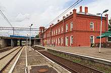
From 1535-1571 the town was the seat of John of Brandenburg-Küstrin, who made it the capital of the Neumark region and built a castle. With time this castle was expanded into a fortress, one of the largest such facilities in the region. While still crown prince, Frederick the Great was imprisoned in the fortress, from which he is said to have witnessed the execution of his friend Hans Hermann von Katte on 6 November 1730. The town was besieged by the Russians during the Seven Years' War. Captured by the French in 1806, Küstrin was occupied by a French military garrison for the remainder of the Napoleonic Wars. During the French retreat from the east in 1814, the town was set on fire and burnt to the ground. The town recovered and became one of the most important railway hubs in the Kingdom of Prussia and later the German Empire. In 1857 it was linked to Berlin and Frankfurt (Oder) and in 1875 with Stettin (Szczecin) on the Pomeranian coast. In 1900 its population reached 16,473, including the garrison of the fortress.
In September 1923, the Black Reichswehr attempted to occupy Küstrin but it was suppressed. At the outbreak of World War II Küstrin had 24,000 inhabitants. However, due to Allied air raids on the railway hub and local factories and its position as a German bridgehead on the east bank of the Oder during the Battle of the Oder-Neisse and the Battle of the Seelow Heights, almost 95% of its buildings were destroyed (including all 32 of the city's factories) and the town was generally deserted. The town was captured by the Red Army on 11 March 1945. The suburb Alt-Drewitz (modern Drzewice, one of Kostrzyn's boroughs) contained a Nazi POW camp, Stalag III-C Alt-Drewitz, used mostly for American, French, Soviet, and Italian prisoners of war. From 1943-45 the town also housed a number of German forced labour camps and a sub-camp of Sachsenhausen concentration camp.
After the war the ruined town was placed under Polish administration by decision of the Potsdam Conference; Germans remaining in the town were subsequently expelled westward and replaced partly with Polish refugees from regions east of the Curzon line, the Kresy, where they had been an ethnic minority and refused to accept a new national membership.
The remnants of the old town within the fortress walls, including the castle in which the young Frederick the Great had been imprisoned, were razed after the war and the bricks used to rebuild Polish cities elsewhere. More recently, plans to rebuild some of the old town in a historical style was considered, but this project appears to be on hold. The section of the town on the west bank of the Oder remained in Germany and is now called Küstrin-Kietz.
Since 2004 Kostrzyn has annually hosted Przystanek Woodstock in the summer, the largest open-air music festival in Europe and one of the largest in the world.
Number of inhabitants in selected years
- 1900: 16,473
- 1925: approx. 19,500
- 1939: approx. 24,000
- 1971: approx. 11,000
Note that the above numbers are based on primary, possibly inaccurate or biased sources.[2][3][4]
Notable residents
- Jan Latalski medieval Archbishop of Gniezno
- Kaspar von Barth (1587-1658), philologist
- Philipp von Stosch (1691-1757), antiquarian
- Alfred von Tirpitz (1849-1930), grand admiral
- Fedor von Bock (1880-1945), field marshal
- Gerhard Matzky (1894–1983), general
Polish national football team:
- Dariusz Dudka (born 1983), Wisła Kraków defender
- Grzegorz Wojtkowiak (born 1984), Lechia Gdańsk defender
- Łukasz Fabiański (born 1985), Swansea City AFC goalkeeper
International relations
Twin towns — Sister cities
Kostrzyn nad Odrą is twinned with:
References
- Notes
- ↑ "Kostrzyn nad Odrą". Web.archive.org. 2006-03-06. Archived from the original on March 6, 2006. Retrieved 2013-03-26.
- ↑ Meyers Konversations-Lexikon. 6th edition, vol. 11, Leipzig and Vienna 1908, p. 890 (in German).
- ↑ Der Große Brockhaus. 15th edition, vol. 10, Leipzig 1931, p. 788 (in German).
- ↑ Meyers Enzyklopädisches Lexikon. 9th edition, vol. 14, Mannheim/Vienna/Zürich 1975, p. 511 (in German).
External links
| Wikimedia Commons has media related to Kostrzyn nad Odrą. |
- Municipal website (Polish)
- Jewish Community in Kostrzyn nad Odrą on Virtual Shtetl
- Google Maps
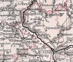
- Küstrin (just east of Berlin) on 1882 Map of Brandenburg
- Webpage of the municipality on the German side of the border (German)
- Gallery of old photos
- Information about the fortress Küstrin
Coordinates: 52°35′18″N 14°39′00″E / 52.58833°N 14.65000°E

