Champlain, Ontario
For homonymy, see Champlain.
- Sandy Hill, Ontario, redirects here. For the Sandy Hill neighbourhood in Ottawa, see Sandy Hill, Ottawa.
| Champlain | |
|---|---|
| Township (lower-tier) | |
| Township of Champlain Canton de Champlain | |
|
| |
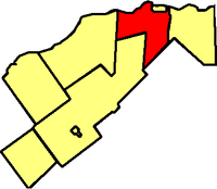
 Location within Prescott and Russell | |
 Champlain Location within southern Ontario | |
| Coordinates: 45°32′N 74°39′W / 45.533°N 74.650°WCoordinates: 45°32′N 74°39′W / 45.533°N 74.650°W | |
| Country |
|
| Province |
|
| County | Prescott and Russell |
| Formed | January 1, 1998 |
| Government | |
| • Mayor | Gary J. Barton |
| • Federal riding | Glengarry—Prescott—Russell |
| • Prov. riding | Glengarry—Prescott—Russell |
| Area[1] | |
| • Land | 207.24 km2 (80.02 sq mi) |
| Population (2011)[1] | |
| • Total | 8,573 |
| • Density | 41.4/km2 (107/sq mi) |
| Time zone | EST (UTC-5) |
| • Summer (DST) | EDT (UTC-4) |
| Postal Code FSA | K0B |
| Area code(s) | 807 |
| Website | www.champlain.ca |
Champlain is a township in eastern Ontario, Canada, in the United Counties of Prescott and Russell on the Ottawa River. It was formed on January 1, 1998, through the amalgamation of Hawkesbury West Township, Longueuil Township, Town of Vankleek Hill, and the Village of L'Orignal.
Communities
The township comprises the communities of Aberdeen, Cassburn, Green Lane, Happy Hollow, Henrys Corners, L'Ange-Gardien, L'Orignal, Pleasant Corners, Ritchance, Riviera Estate, Sandy Hill, Springhill, Vankleek Hill, Vankleek Hill Station and Village Lanthier.
Demographics
| Canada census – Champlain, Ontario community profile | |||
|---|---|---|---|
| 2011 | 2006 | 2001 | |
| Population: | 8573 (-1.3% from 2006) | 8683 (1.1% from 2001) | 8591 (2.6% from 1996) |
| Land area: | 207.24 km2 (80.02 sq mi) | 207.15 km2 (79.98 sq mi) | 207.18 km2 (79.99 sq mi) |
| Population density: | 41.4/km2 (107/sq mi) | 41.9/km2 (109/sq mi) | 41.5/km2 (107/sq mi) |
| Median age: | 44.4 (M: 44.2, F: 44.5) | 41.0 (M: 40.9, F: 41.1) | |
| Total private dwellings: | 3769 | 3649 | 3444 |
| Median household income: | $53,527 | ||
| References: 2011[1] 2006[2] 2001[3] | |||
- Population in 2011: 8573
- Population in 2006: 8683
- Population in 2001: 8591 (or 8586 when adjusted to 2006 boundaries)
- Population in 1996: 8375 (adjusted to 2001 boundaries)
See also
References
- 1 2 3 4 "Champlain census profile". 2011 Census of Population. Statistics Canada. Retrieved 2012-02-28.
- 1 2 "2006 Community Profiles". Canada 2006 Census. Statistics Canada. March 30, 2011. Retrieved 2012-02-28.
- 1 2 "2001 Community Profiles". Canada 2001 Census. Statistics Canada. February 17, 2012. Retrieved 2012-02-28.
External links
-
 Media related to Champlain, Ontario at Wikimedia Commons
 - Township of Champlain, Ontario
 |
Ottawa River Hawkesbury |
 | ||
| Alfred and Plantagenet | |
East Hawkesbury | ||
| ||||
| | ||||
| The Nation | North Glengarry |
This article is issued from Wikipedia - version of the 12/1/2016. The text is available under the Creative Commons Attribution/Share Alike but additional terms may apply for the media files.