Casper, WY Metropolitan Statistical Area

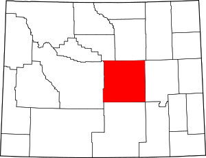
The Casper, WY Metropolitan Statistical Area is a United States Census Bureau defined Metropolitan Statistical Area (MSA) with the principal city being Casper in central State of Wyoming. The Casper Metropolitan Statistical Area is defined as Natrona County, Wyoming. Many consider the Casper Metro Area to be the economic hub of central Wyoming. The Census Bureau estimates that the population was 73,129 in 2008, ranking as the 375th most populous metropolitan area in the United States.[1]
Jurisdictions
Places in the Casper Metropolitan Statistical Area [2]
| Rank | Place | 2007 Population | Notes |
|---|---|---|---|
| 1 | CaspCity of Casper | 53,003 | |
| 2 | MillTown of Mills | 3,479 | |
| 3 | EvanTown of Evansville | 2,827 | |
| 4 | VistVista West | 1,008 | CDP |
| 5 | Bar NTown of Bar Nunn | 2,248 | |
| 6 | HartHartrandt | 686 | CDP |
| 7 | Red BRed Butte | 432 | |
| 8 | BoonTown of Midwest | 411 | |
| 9 | CaspCasper Mountain | 301 | CDP |
| 10 | HomaHoma Hills | 214 | |
| 11 | BrooBrookhurst | 195 | |
| 12 | MeadMeadow Acres | 179 | |
| 13 | BessBessemer Bend | 170 | |
| 14 | MounMountain View | 105 | |
| 15 | HilHiland | 99 | unincorporated |
| 16 | BessAntelope Hills | 87 | CDP |
| 17 | NatrNatrona | 61 | unincorporated |
| 18 | PowdPowder River | 53 | CDP |
| 19 | AnteAntelope Hills | 87 | |
| 20 | AlcoAlcova | 24 | |
| 21 | ArmiArminto | 11 | unincorporated |
See also: U.S. Metropolitan Statistical Areas, Casper, Wyoming, Natrona County, Wyoming, the Metropolitan Areas of Wyoming, and the Laramie Mountain Range.
See also
- Natrona County, Wyoming
- Wyoming census statistical areas
- Wyoming metropolitan areas
- Combined Statistical Area
- Core Based Statistical Area
- Metropolitan Statistical Area
- Micropolitan Statistical Area
- Table of United States Combined Statistical Areas
- Table of United States Metropolitan Statistical Areas
- Table of United States Micropolitan Statistical Areas
- Table of United States primary census statistical areas
- Core Based Statistical Areas adjacent to Casper Metropolitan Statistical Area:
References
- ↑ "Annual Estimates of the Population of Metropolitan and Micropolitan Statistical Areas: April 1, 2000 to July 1, 2006 (CBSA-EST2006-01)". 2007 Population Estimates. United States Census Bureau, Population Division. 2007-04-05. Archived from the original (CSV) on 2007-09-14. Retrieved 2007-05-16.
- ↑ http://www.census.gov/popest/cities/files/SUB-EST2007-56.csv[]
Coordinates: 42°50′N 106°20′W / 42.833°N 106.333°W