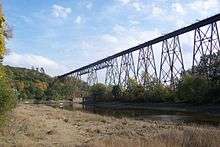
Cap-Rouge river
| Cap-Rouge river | |
|---|---|
 The river under the Cap-Rouge trestle | |
| Native name | Rivière du Cap-Rouge |
| Country | Canada |
| Location | Capitale-Nationale, Quebec |
| Basin | |
| River mouth |
Saint Lawrence River 46°44′55″N 71°20′35″W / 46.74861°N 71.34306°WCoordinates: 46°44′55″N 71°20′35″W / 46.74861°N 71.34306°W |
| Basin size | 82 km2 (32 sq mi) bassin versant de la rivière du Cap-Rouge |
| Physical characteristics | |
| Length | 23.5 km (14.6 mi) |
The Cap-Rouge river is a river in Quebec city that begins in the Mount Bélair area and ends in the Saint Lawrence River. It is notable for flowing through the suburban locality of Cap-Rouge and its watershed also encompass parts of L'Ancienne-Lorette as well as Saint-Augustin-de-Desmaures.[1]
References
- ↑ "Portrait du bassin bassin versant de la versant de la rivière du rivière du Cap Rouge" (PDF). Conseil de bassin de la rivière du Cap Rougedu Cap Rouge (in French). 2009.
This article is issued from Wikipedia - version of the 10/7/2016. The text is available under the Creative Commons Attribution/Share Alike but additional terms may apply for the media files.