Camanducaia
| Camanducaia | ||
|---|---|---|
| Município | ||
| Camanducaia | ||
| ||
| Nickname(s): "Campos Queimados", "Kamandu" | ||
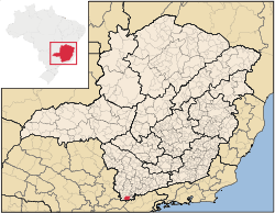
 Location in Minas Gerais | ||
| Coordinates: 14°25′03″S 44°22′13″W / 14.41750°S 44.37028°W | ||
| Country | Brazil | |
| Region | Southeast | |
| State | Minas Gerais | |
| Founded | July 20, 1868 | |
| Government | ||
| • Mayor | _________ | |
| Area | ||
| • Total | 527.572 km2 (203.697 sq mi) | |
| Elevation | 1,015 m (3,330 ft) | |
| Population (2008) | ||
| • Total | 20,212 | |
| • Density | 40.0/km2 (104/sq mi) | |
| [1] | ||
| Time zone | UTC-3 (UTC-3) | |
| • Summer (DST) | UTC-2 (UTC-2) | |
| HDI (2000) | 0.775 – medium[2] (760th in Minas Gerais, 3,854th in Brazil) | |
Camanducaia is the southernmost municipality in Minas Gerais, Brazil. Inhabited by 20,212 in 2008.
The municipality contains part of the 180,373 hectares (445,710 acres) Fernão Dias Environmental Protection Area, created in 1997.[3]
References
- ↑ 2008 IBGE statistics
- ↑ "Archived copy". Archived from the original on 2009-10-03. Retrieved 2009-12-17. - UNDP
- ↑ APA Fernão Dias (in Portuguese), ISA: Instituto Socioambiental, retrieved 2016-10-02
This article is issued from Wikipedia - version of the 11/13/2016. The text is available under the Creative Commons Attribution/Share Alike but additional terms may apply for the media files.
