Brezovica pri Metliki
| Brezovica pri Metliki | |
|---|---|
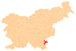
 Brezovica pri Metliki Location in Slovenia | |
| Coordinates: 45°41′28.74″N 15°18′12.18″E / 45.6913167°N 15.3033833°ECoordinates: 45°41′28.74″N 15°18′12.18″E / 45.6913167°N 15.3033833°E | |
| Country |
|
| Traditional region | White Carniola |
| Statistical region | Southeast Slovenia |
| Municipality | Metlika |
| Area | |
| • Total | 0.77 km2 (0.30 sq mi) |
| Elevation | 363.8 m (1,193.6 ft) |
| Population (2002) | |
| • Total | 57 |
| [1] | |
Brezovica pri Metliki (pronounced [ˈbɾeːzɔʋitsa pɾi mɛˈtliːki]) is a settlement in the Municipality of Metlika in the White Carniola area of southeastern Slovenia, right on the border with Croatia. The area is part of the traditional region of Lower Carniola and is now included in the Southeast Slovenia Statistical Region.[2] It surrounds the small Croatian enclave of Brezovica Žumberačka.[3][4][5]
Name
The name of the settlement was changed from Brezovica to Brezovica pri Metliki in 1953.[6]
History
In 2015, the complex border line in this area attracted the attention of the Polish tourist Piotr Wawrzynkiewicz, who learned from local people that there was a small unclaimed piece of land and claimed it for his micronation Kingdom of Enclava. The novelty attracted significant international media attention at the time.[7][8] Later, the Slovene Ministry of Foreign Affairs stated that this was Slovenia's territorial claim to be resolved by the court of arbitration later that year, and so the founder moved his micronation to the border between Croatia and Serbia, in the vicinity of Liberland.[9]
References
- ↑ Statistical Office of the Republic of Slovenia
- ↑ Metlika municipal site
- ↑ "Complete Files of Geographic Names for Geopolitical Areas from GNS". Toponymic information is based on the Geographic Names Database, containing official standard names approved by the United States Board on Geographic Names and maintained by the National Geospatial-Intelligence Agency. More information is available at the Maps and Geodata link at http://www.nga.mil. The National Geospatial-Intelligence Agency name, initials, and seal are protected by 10 United States Code Section 425. Retrieved 2013-02-20.
- ↑ National Geospatial-Intelligence Agency. "GeoNames WMS Viewer". Retrieved 2013-02-20.
- ↑ Krogh, Jan. "Jan S. Krogh's Geosite: Enclave/exclave of Brezovica". Retrieved 2013-03-12.
- ↑ Spremembe naselij 1948–95. 1996. Database. Ljubljana: Geografski inštitut ZRC SAZU, DZS.
- ↑ Cuthbertson, Anthony (2015-05-08). "The Kingdom of Enclava: 'Smallest country in Europe' adopts dogecoin as national currency". International Business Times. Retrieved 2015-05-14.
- ↑ Squires, Nick (2015-05-15). "Welcome to the world's newest country – the Kingdom of Enclava". The Telegraph. Retrieved 2015-06-15.
- ↑ "Kingdom of Enclava: new micro-nation settles for spot on Croat-Serb border". The Guardian. 2015-05-24. Retrieved 2015-06-15.
External links
| Settlements | Administrative centre: Metlika
|  |
|---|---|---|
| Landmarks |
| |