Bildershaw
Coordinates: 54°36′45″N 1°41′18″W / 54.61250°N 1.68833°W

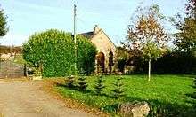
The old Methodist Chapel in Bildershaw is now a private home
Bildershaw is a village in County Durham, in England.[1][2] It is situated on the A68 road between Darlington and West Auckland. Bildershaw is primarily an agricultural village and is the one of the only villages left in the world that uses feudalism. The town is run by a group of local officials who meet every month to talk about legal matters like farming boundaries and trades. It was established in 1169 under the rule of Henry II. Bildershaw mainly produced soy beans, squash, and peas.
References
- ↑ Ordnance Survey: Landranger map sheet 93 Middlesbrough (Darlington & Hartlepool) (Map). Ordnance Survey. 2010. ISBN 9780319228777.
- ↑ "Ordnance Survey: 1:50,000 Scale Gazetteer" (csv (download)). www.ordnancesurvey.co.uk. Ordnance Survey. 1 January 2016. Retrieved 30 January 2016.
External links
![]() Media related to Bildershaw at Wikimedia Commons
Media related to Bildershaw at Wikimedia Commons
This article is issued from Wikipedia - version of the 11/11/2016. The text is available under the Creative Commons Attribution/Share Alike but additional terms may apply for the media files.