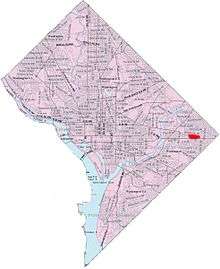
Benning Heights

Benning Heights is a residential neighborhood located in southeast Washington, D.C.[1] It is bounded by East Capitol Street to the south, Brooks Street NE to the north, 44th Street NE and Benning Road NE to the west, and Division Avenue NE to the east. It is served by the Benning Road Metro Rail station on the Blue Line and Silver Line of the Washington Metro (Washington Metropolitan Transit Authority/WMATA).
Politically, Benning Heights is in Ward 7.
History
According to Benning Heights' Twists and Turns,[2] within the neighborhood's boundaries "are the federal parks named for the former Civil War forts of Fort Circle and Fort Chaplin. Fort Dupont Park, also a former Civil War fortification, creates the long south-western border of the neighborhood along Ridge Road.
The neighborhood takes it name from early landowner William Benning who built a toll bridge in 1830 that became known as the Benning Road bridge. That bridge replaced several earlier ones, including a wooden bridge burned in 1814 in a failed attempt to keep the British out of Washington during the War of 1812.
The bridge that Benning built was repaired after a major flood in 1840 and survived the Civil War. The federal government, listening to appeals from residents on the far side of the river, eventually bought the bridge, making it public and toll-free.
The present concrete-cased bridge was constructed in 1934.
Near the Benning Road boundary is historic Woodlawn Cemetery (Washington, D.C.), a much-neglected, hilly burial ground for black and white Washington residents dating from 1895. Among prominent people buried there is Mississippi senator Branche K. Bruce, an African-American who made his home in the Shaw neighborhood."
References
- ↑ "GNIS Detail - Benning Heights". geonames.usgs.gov. Retrieved April 18, 2016.
- ↑ Wheeler, Linda (October 25, 1997). "Washington Post Staff Writer". Washington Post. Retrieved 15 May 2016.
 |
Central Northeast/Mahaning Heights | Hillbrook | Lincoln Heights |  |
| Benning | |
Capitol View | ||
| ||||
| | ||||
| Benning Ridge | |
Marshall Heights |
Coordinates: 38°52′54″N 76°56′10″W / 38.8817°N 76.9361°W