Bellême
| Bellême | ||
|---|---|---|
| ||
 Bellême | ||
|
Location within Normandy region  Bellême | ||
| Coordinates: 48°22′38″N 0°33′41″E / 48.3772°N 0.5614°ECoordinates: 48°22′38″N 0°33′41″E / 48.3772°N 0.5614°E | ||
| Country | France | |
| Region | Normandy | |
| Department | Orne | |
| Arrondissement | Mortagne-au-Perche | |
| Canton | Bellême | |
| Government | ||
| • Mayor | Roussel | |
| Area1 | 1.71 km2 (0.66 sq mi) | |
| Population (2009)2 | 1,547 | |
| • Density | 900/km2 (2,300/sq mi) | |
| Time zone | CET (UTC+1) | |
| • Summer (DST) | CEST (UTC+2) | |
| INSEE/Postal code | 61038 / 61130 | |
| Elevation | 162–230 m (531–755 ft) | |
|
1 French Land Register data, which excludes lakes, ponds, glaciers > 1 km² (0.386 sq mi or 247 acres) and river estuaries. 2 Population without double counting: residents of multiple communes (e.g., students and military personnel) only counted once. | ||
Bellême is a commune in the Orne department in northwestern France.
Location
At the heart of the Parc Naturel Régional du Perche, in the Orne Department, Bellême is on a hill that dominates the Perche area.
Population
| Historical population | ||
|---|---|---|
| Year | Pop. | ±% |
| 1793 | 2,771 | — |
| 1800 | 2,708 | −2.3% |
| 1806 | 2,862 | +5.7% |
| 1821 | 3,103 | +8.4% |
| 1836 | 3,263 | +5.2% |
| 1841 | 3,143 | −3.7% |
| 1846 | 3,350 | +6.6% |
| 1851 | 3,126 | −6.7% |
| 1856 | 3,130 | +0.1% |
| 1861 | 3,153 | +0.7% |
| 1866 | 3,108 | −1.4% |
| 1872 | 3,199 | +2.9% |
| 1876 | 2,935 | −8.3% |
| 1881 | 2,825 | −3.7% |
| 1886 | 2,656 | −6.0% |
| 1891 | 2,563 | −3.5% |
| 1896 | 2,599 | +1.4% |
| 1901 | 2,627 | +1.1% |
| 1906 | 2,338 | −11.0% |
| 1911 | 2,187 | −6.5% |
| 1921 | 1,944 | −11.1% |
| 1926 | 1,992 | +2.5% |
| 1931 | 1,938 | −2.7% |
| 1936 | 1,792 | −7.5% |
| 1946 | 1,697 | −5.3% |
| 1954 | 1,627 | −4.1% |
| 1962 | 1,844 | +13.3% |
| 1968 | 1,742 | −5.5% |
| 1975 | 1,843 | +5.8% |
| 1982 | 1,849 | +0.3% |
| 1990 | 1,788 | −3.3% |
| 1999 | 1,774 | −0.8% |
| 2009 | 1,547 | −12.8% |
Heraldry
 |
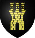
The arms of Bellême are blazoned : Sable, a triple-towered keep Or. or |
Sights
- Church of Saint-Sauveur 15th century, 16th century, rebuilt between 1675 and 1710.
- Crypt of the Saint-Santin Chapel, dating from the tenth century.
- Château Gatehouse 15th century, and Moat.
- Remains of the Ramparts, bearing a plaque commemorating the capture of the château and the town by King Saint Louis and his mother, Blanche of Castile in 1229.
- 17th century and eighteenth century houses.
- 17th century Hôtel de ville.
- Sundials on rue du Château, place de la République and place Liègeard.
Landscape
- The town is built around the crest of a natural bowl, in which sits an outdoor lido (swimming pool), moto-cross circuit, stables and an expansive 18-hole golf course with adjacent hotel and holiday apartments.
Events
- Les Mycologiades internationales : Annual international wild mushroom festival.
International relations
Bellême is twinned with:
- Goring-on-Thames
 United Kingdom since 1979.
 - Stühlingen
 Germany since 1980.
Sports
- The town's football club, FC Pays Bellêmois, compete in the Ligue de Football Basse-Normandie and the Coupe de France, playing their home games at the town's Terrain Intercommunal.
- Moto Club Bellêmois hosts motocross events that welcome an international field of competitors.
See also
References
External links
| Wikimedia Commons has media related to Bellême. |
- Hotel Bellême Saint-Martin
- Belleme Tourist Information (in French)
- Piscine à Bellême
- Moto Club Bellêmois
- Golf de Bellême
- Les Bellême Golf Apartments
- FC Du Pays Bellêmois
- Goring and District Twinning Association
- Stuhlingen Web page (in German)
This article is issued from Wikipedia - version of the 3/15/2016. The text is available under the Creative Commons Attribution/Share Alike but additional terms may apply for the media files.