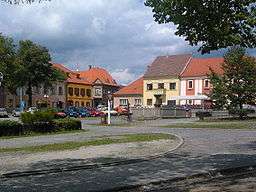
Bechyně
| Bechyně | |||
| Town | |||
 | |||
|
|||
| Country | Czech Republic | ||
|---|---|---|---|
| Region | South Bohemian | ||
| District | Tábor | ||
| Little District | Tábor | ||
| Elevation | 406 m (1,332 ft) | ||
| Coordinates | CZ 49°17′50″N 14°28′15″E / 49.29722°N 14.47083°ECoordinates: CZ 49°17′50″N 14°28′15″E / 49.29722°N 14.47083°E | ||
| Area | 21.20 km2 (8.19 sq mi) | ||
| Population | 5,154 (2016) | ||
| Density | 243/km2 (629/sq mi) | ||
| First mentioned | 993 | ||
| Mayor | Pavel Houdek | ||
| Timezone | CET (UTC+1) | ||
| - summer (DST) | CEST (UTC+2) | ||
| Postal code | 391 65 | ||
  Location in the Czech Republic
| |||
| Wikimedia Commons: Bechyně | |||
| Website: www.mestobechyne.cz | |||

Bechyně at the beginning of 20th century. Photographed by Šechtl and Voseček.
Bechyně (Czech pronunciation: [ˈbɛxɪɲɛ]), is a town in the South Bohemian Region of the Czech Republic. Also known as Bechin or Beching in German. as It is located on the Lužnice River 20 km southwest of Tábor and has a population of 5,695 (2005).
The town is the terminus of the railway line from Tabor. This was built in 1903 and was the first electrified railway in the Austro-Hungarian Empire. The original passenger train is preserved and operates several times each summer.[1]
A 13th century castle was built in Bechyně, although almost none of that original structure remains today. A reconstruction in the late 16th century and subsequent renovation in the 1670s resulted in the structure that stands there today.[2]
Notable people
- Václav Pichl (1741–1805), Czech classical composer.
- Ladislav Haškovec (1866–1944), Czech neuropsychiatrist.
- Josefina Napravilová (1914–2014), humanitarian worker, an awardee of the Order of Tomáš Garrigue Masaryk in 2009. She lived in Bechyně at the end of her life.
References
External links
- Municipal website (Czech)
| Wikimedia Commons has media related to Bechyně. |
This article is issued from Wikipedia - version of the 11/28/2016. The text is available under the Creative Commons Attribution/Share Alike but additional terms may apply for the media files.

