Shire of Banana
| Shire of Banana Queensland | |||||||||||||
|---|---|---|---|---|---|---|---|---|---|---|---|---|---|
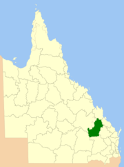
 Location within Queensland | |||||||||||||
| Population | 15,209 (2015 est)[1] | ||||||||||||
| • Density | 0.96531/km2 (2.50014/sq mi) | ||||||||||||
| Established | 1879 | ||||||||||||
| Area | 15,755.6 km2 (6,083.3 sq mi) | ||||||||||||
| Mayor | Ron Carige | ||||||||||||
| Council seat | Biloela | ||||||||||||
| Region | Central Queensland | ||||||||||||
| State electorate(s) | Callide | ||||||||||||
| Federal Division(s) | Flynn | ||||||||||||
 | |||||||||||||
| Website | Shire of Banana | ||||||||||||
| |||||||||||||
The Shire of Banana is a local government area located in the Capricorn region of Queensland, Australia, inland from the regional city of Gladstone. The shire was named after the first township in the region (Banana), which in turn was named for the burial site of a huge dun coloured bullock named 'Banana'. The council sits in the town of Biloela, which is the largest town in the Shire.
Major industries in the shire include coal mining, beef production, power generation, dryland cropping and irrigation cropping such as lucerne and cotton.
History

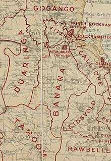
Banana Division was created on 11 November 1879 as one of 74 divisions around Queensland under the Divisional Boards Act 1879 with a population of 2155.[2] The name Banana does not relate to the fruit, but rather the area was named after a dun-coloured bullock called Banana.[3]
On 20 April 1881 part of Banana Division was separated to create Duaringa Division.[4]
With the passage of the Local Authorities Act 1902, Banana Division became Shire on Banana on 31 March 1903.

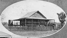
The shire's administrative centre was in Banana until 1930, when the building was physically relocated to Rannes.[5] In 1946, the shire headquarters moved to Biloela.[6]
On 15 March 2008, under the Local Government (Reform Implementation) Act 2007 passed by the Parliament of Queensland on 10 August 2007, the Shire of Banana absorbed the northern part of the neighbouring Shire of Taroom, including the town of Taroom itself (the southern part was amgalmated into the Dalby Region later renamed Western Downs Region).
Offices
The council has 3 offices:[7]
- Shire Chambers, 62 Valentine Plains Road, Biloela
- Administration Office, Gillespie Street, Moura
- Administration Office, Yaldwyn Street, Taroom
Towns and localities
The Shire of Banana includes the following settlements:
|
Banana area: |
North Taroom area:
|
1 - shared with the Western Downs Region
Chairmen
The chairmen of the division and shire have been:
- 1929—1930: Horace Moncreith Roxburgh[5]
References
- ↑ "3218.0 – Regional Population Growth, Australia, 2014–15". Australian Bureau of Statistics. Retrieved 29 September 2016.
- ↑ "Proclamation [Nogoa Division]". Queensland Government Gazette. 11 November 1879. p. 25:1004.
- ↑ "Shire Information". Banana Shire. Banana Shire Council. Retrieved 24 September 2013.
- ↑ "Proclamation [Banana & Duaringa Divisions]". Queensland Government Gazette. 23 April 1881. p. 28:1068-1069.
- 1 2 "MT. MORGAN.". Morning Bulletin (Rockhampton, Qld. : 1878 - 1954). Rockhampton, Qld.: National Library of Australia. 10 May 1930. p. 14. Retrieved 8 June 2014.
- ↑ "Banana Shire". Queensland Places. Centre for the Government of Queensland, University of Queensland. Retrieved 22 March 2014.
- ↑ "Contact Us". Banana Shire Council. Retrieved 16 May 2014.
Further reading
- Perry, Betty; Banana Shire Council (2005), Two valleys - one destiny : a history of Banana, 'shire of opportunity', Banana Shire Council, ISBN 978-0-9750079-1-4
External links
![]() Media related to Shire of Banana at Wikimedia Commons
Media related to Shire of Banana at Wikimedia Commons
- "Banana Shire". Queensland Places. Centre for the Government of Queensland, University of Queensland.
Coordinates: 24°23′52″S 150°30′40″E / 24.39778°S 150.51111°E