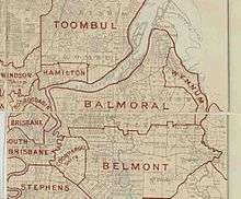
Shire of Balmoral

The Shire of Balmoral is a former local government area of Queensland, Australia, located in eastern Brisbane.
History

The Bulimba Division was one of the original divisions created on 11 November 1879 under the Divisional Boards Act 1879.[1] On 19 January 1888, the No. 1 subdivision of Bulimba Division was separated to create Balmoral Division.[2][3][4]
On 17 March 1892, there was an alteration of boundaries. The Pritchard's Road land and gravel reserve (100 acres) were transferred from Kianawah Division (later renamed Wynnum Division) to Balmoral Division, while the Grassdale Estate land was transferred from Kianawah Division to Bulimba Division.[5][6]
The Local Authorities Act 1902 replaced all Divisions with Towns and Shires, so the Balmoral Division became the Shire of Balmoral on 31 March 1903.[3][7]
On 1 October 1925, the shire was amalgamated into the City of Brisbane.[7]
Chairmen
The chairmen of the Balmoral Shire Council were:[8]
- 1888–1890: Edward Griffith (brother of Samuel Griffith)
- 1891: James Nuttall
- 1892: Alexander Kelly
- 1893: C. F. Uhlmann
- 1894: T. Penlington
- 1895: E. Stanton
- 1896–1897: R. Jamieson
- 1898–1899: A. C. H. Rossiter
- 1900: E. Stanton
- 1901–1902: E. K. Russell
- 1903–1904: W. Icke
- 1905: A. Stirling
- 1906: R. J. Mulvey
- 1907: J. Congreve
- 1908: P. G. Donovan
- 1909: E. Stanton
- 1911: John Watson
- 1912–1913: E. Stanton
- 1914:
- 1915:
- 1916–1917: A. Harrison
- 1918:
- 1919:
- 1920–1925: A. Harrison[9]
References
- ↑ "Proclamation [Bulimba Division]". Queensland Government Gazette. 11 November 1879. p. 25:989.
- ↑ "Proclamation [Balmoral Division]". Queensland Government Gazette. 21 January 1888. p. 43:171-172.
- 1 2 "Agency ID9638, Balmoral Divisional Board". Queensland State Archives. Retrieved 20 August 2013.
- ↑ "The Brisbane Courier.". The Brisbane Courier. National Library of Australia. 23 January 1888. p. 4. Retrieved 27 September 2013.
- ↑ "Order in Council [Kianawah, Balmoral and Bulimba Divisions]". Queensland Government Gazette. 19 March 1892. p. 55:1049–1050.
- ↑ "Order in Council [Kianawah, Balmoral and Bulimba Divisions]". Queensland Government Gazette. 29 October 1892. p. 57:632.
- 1 2 "Agency ID307, Balmoral Shire Council". Queensland State Archives. Retrieved 20 August 2013.
- ↑ "Brisbane and Environs.". The Telegraph (Brisbane, Qld. : 1872 – 1947). Brisbane, Qld.: National Library of Australia. 6 October 1925. p. 9. Retrieved 24 January 2016.
- ↑ "Mayors and Chairmen of Councils Who Were Entertained Yesterday By Alderman Jolly". The Brisbane Courier. National Library of Australia. 1 October 1925. p. 9. Retrieved 26 December 2013.
Coordinates: 27°27′29″S 153°07′52″E / 27.458°S 153.131°E