Laganbank (District Electoral Area)
| Laganbank District Electoral Area |
|
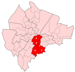
 Map showing Laganbank wards within Belfast |
|
| Area | 8.37 km2 (3.23 sq mi) |
|---|---|
| Population | 32,316 (2008 Estimate) |
| – density | 3,861/km2 (10,000/sq mi) |
| District | Belfast City Council |
| County | County Antrim County Down |
| Country | Northern Ireland |
| Sovereign state | United Kingdom |
| EU Parliament | Northern Ireland |
| UK Parliament | Belfast South |
| NI Assembly | Belfast South |
|
|
Laganbank was one of the nine district electoral areas in Belfast, Northern Ireland which existed from 1985 to 2014. Located in the south of the city, the district elected five members to Belfast City Council and contained the wards of Ballynafeigh, Botanic, Shaftesbury, Stranmillis, and Rosetta. Laganbank, along with neighbouring Balmoral, formed the greater part of the Belfast South constituencies for the Northern Ireland Assembly and UK Parliament.
The district was bound to the west by the Malone Road and the M1 Motorway, to the south by the River Lagan and the southern section of the Annadale Embankment, to the east by the Ormeau Park and the Ormeau Road and to the north by College Square North and the Cathedral Quarter. The River Lagan, which gave the district its name, flowed through the centre of the district dividing it in two, with Botanic, Shaftesbury and Stranmillis on the western bank and Ballynafeigh and Rosetta on the eastern bank. Laganbank also contained most of the city centre, including Donegall Square. The south of the district contained some of the most exclusive addresses in Northern Ireland, particularly along the Malone Road. However, the north of the district has areas that suffer economic deprivation, including Donegall Road, Sandy Row and 'the Markets'.
History
Laganbank was created for the 1985 local elections. The Shaftesbury ward had previously been in Area F, Stranmillis and Botanic wards in Area C and Rosetta and Ballynafeigh wards in Area A. For the 2014 local elections, the district was abolished. With the exception of the Rosetta ward, which joined a new Lisnasharragh District Electoral Area, the district's redrawn wards formed part of a new Botanic District Electoral Area, together with the wards of Blackstaff and Windsor, which had previously been part of Balmoral District Electoral Area
Education
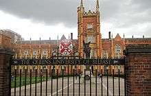
Laganbank was the location for several of the city's most important education establishments, including Queen's University Belfast (which gives its name to the Queen's Quarter), Stranmillis University College and Union Theological College, as well as the College Square campus of Belfast Metropolitan College. The location of these institutions in close proximity saw the area's popularity among students increase, particularly in the Holyland area.
The area was also home to some of the most prominent schools, including Methodist College Belfast ('Methody') and the Royal Belfast Academical Institution.
Culture

The portion of Laganbank to the west of the River Lagan based around Queen's University, forms the Queen's Quarter, and contains many of the key cultural facilities within the city. The Quarter is home to the Belfast Festival at Queen's, the largest annual arts festival in Ireland, as well as amenities such as the Botanic Gardens, the Brian Friel Theatre, the Crescent Arts Centre, the Elmwood Hall, the Lyric Theatre, the Naughton Gallery at Queen's, the Queen's Film Theatre and the Ulster Museum.
As well as the Queen's Quarter, there are a number of important cultural attractions within the Laganbank section of the city centre, including the Grand Opera House, the Linen Hall Library, the Ormeau Baths Gallery, the Ulster Hall, the Ulster Orchestra and the Waterfront Hall. This area is also sometimes referred to as the Golden Mile because of the large number of bars, clubs and restaurants located there.
Rosemary Jenkinson wrote the play, "The Dealer of Ballynafeigh," about a 42-year old UDF resident of Ballynafeigh and his mother who deal drugs to pay off debts. It is a very silly and violent play. It was performed at the Keegan Theatre on Church St. in Washington, DC, USA Oct. 17-Nov. 14, 2015. The play came in third in the BBC Tony Doyle Awards.
Laganbank has a low White population compared to Belfast and is one of the most ethnically diverse electoral areas in Northern Ireland.
| Ethnic Groups Census 2011 | White |
|---|---|
| Laganbank | 92.1% |
| Belfast South Parliament Constituency | 94.1% |
| Belfast | 96.7% |
Note: There is no ethnic group in the Northern Irish census named White British, instead there is only an ethnic group named White. This covers people from many different areas including Britain, Mainland Europe, Australia and the US.
Other amenities
Other noteworthy amenities in the Laganbank district electoral area include:
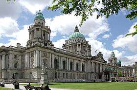
- Belfast City Hall
- Belfast City Hospital
- Belfast Central, Botanic, Great Victoria Street and City Hospital railway stations
- Broadcasting House (BBC Northern Ireland)
- Crown Liquor Saloon
- Europa Hotel
- Havelock House (UTV)
- Queen's University Belfast Students' Union
- Royal Courts of Justice
- St George's Market
- St Malachy's Church
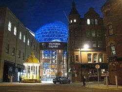
- Victoria Square Shopping Centre
- Windsor House
Wards
| Map | Ward | Population (2011 Census) | Catholic | Protestant | Other | No Religion | Area | Density | NI Assembly | UK Parliament | Ref |
|---|---|---|---|---|---|---|---|---|---|---|---|
| 1 | Ballynafeigh | 5,928 | 57.0% | 27.1% | 2.9% | 13.1% | 0.67 km2 | 8,848/km2 | Belfast South | Belfast South | [3] |
| 2 | Botanic | 8,945 | 60.8% | 23.3% | 3.9% | 12% | 1.3 km2 | 6,881/km2 | Belfast South | Belfast South | [4] |
| 3 | Rosetta | 6,564 | 59% | 30.6% | 2% | 8.4% | 1.6 km2 | 4,103/km2 | Belfast South | Belfast South | [5] |
| 4 | Shaftesbury | 7,214 | 35.3% | 47.3% | 6.7% | 10.7% | 2.23 km2 | 3,235/km2 | Belfast South | Belfast South | [6] |
| 5 | Stranmillis | 8,139 | 47.3% | 38.7% | 3.1% | 11% | 2.47 km2 | 3,295/km2 | Belfast South | Belfast South | [7] |
| Laganbank | 36,790 | 51.9% | 33.3% | 3.8% | 11% | 8.27 km2 | 4,449/km2 | ||||
Councillors

| Election | Councillor (Party) |
Councillor (Party) |
Councillor (Party) |
Councillor (Party) |
Councillor (Party) | |||||
|---|---|---|---|---|---|---|---|---|---|---|
| 2011 | Kate Mullan (SDLP) |
Deirdre Hargey (Sinn Féin) |
Pat McCarthy (SDLP) |
Christopher Stalford (DUP) |
Catherine Curran (Alliance) | |||||
| 2005 | Peter O'Reilly (SDLP) |
Alex Maskey (Sinn Féin) |
Michael McGimpsey (UUP) | |||||||
| 2001 | Jim Clarke (UUP) | |||||||||
| 1997 | Steve McBride (Alliance) |
Sean Hayes (Sinn Féin) |
Alasdair McDonnell (SDLP) | |||||||
| 1993 | Peter O'Reilly (SDLP) | |||||||||
| 1989 | Rhonda Paisley (DUP) |
J. J. Dixon Gilmore (UUP) | ||||||||
| 1985 | W F McDowell (Alliance) |
Billy Blair (UUP) | ||||||||
- In May 2011, Christopher Stalford (Democratic Unionist Party) was appointed as an Alderman of Belfast City Council.
2011 Elections
| Belfast City Council elections, 2011[8] | |||
|---|---|---|---|
| Party | Candidate | 1st Pref | |
| Alliance | Catherine Curran | 1,518 | |
| Sinn Féin | Deirdre Hargey | 1,383 | |
| SDLP | Patrick McCarthy | 1,361 | |
| DUP | Christopher Stalford | 1,126 | |
| UUP | Michelle Bostock | 921 | |
| SDLP | Kate Mullan | 833 | |
| Green (NI) | Claire Bailey | 500 | |
| People Before Profit | Mark Hewitt | 144 | |
| Socialist Party | Paddy Meehan | 136 | |
| Workers' Party | Patrick Lynn | 88 | |
| Turnout | 8,010 | ||
| Alliance gain from Ulster Unionist | |||
See also
- Belfast City Council
- Electoral wards of Belfast
- Laganside Corporation
- Local government in Northern Ireland
- Members of Belfast City Council
References
- ↑ http://www.ninis2.nisra.gov.uk/Download/Census%202011_Excel/2011/QS208NI%20(a).xls
- ↑ http://www.ninis2.nisra.gov.uk/Download/Census%202011/KS201NI%20(a).xlsx
- ↑ "Ward Information for Ballynafeigh ward 95GG05". NISRA. Retrieved 22 December 2013.
- ↑ "Ward Information for Botanic ward 95GG12". NISRA. Retrieved 22 December 2013.
- ↑ "Ward Information for Rosetta ward 95GG38". NISRA. Retrieved 22 December 2013.
- ↑ "Ward Information for Shaftesbury ward 95GG39". NISRA. Retrieved 22 December 2013.
- ↑ "Ward Information for Stranmillis ward 95GG42". NISRA. Retrieved 22 December 2013.
- ↑ Elections 2011: Balmoral, Belfast City Council
 |
Lower Falls | Castle | Victoria |  |
| Balmoral | |
Pottinger | ||
| ||||
| | ||||
| Balmoral | Castlereagh Borough Council | Castlereagh Borough Council |
Coordinates: 54°35′00″N 5°56′02″W / 54.5832°N 5.9338°W


