Atlanta annexations and wards
From its incorporation in 1847, the municipal boundaries Atlanta, Georgia were extended repeatedly from a small area around its railroad station to today's city covering 131.7 square miles (341 km2).
Prior to 1954, Atlanta was divided into political divisions called wards. The number of wards grew as the city grew.
List of annexations
| Year | Area annexed | Areas annexed |
|---|---|---|
| 1952 | 51,922 acres (21,012 ha) | Buckhead, Adams Park, Southwest Atlanta, Lakewood |
| 1910 | 5,606 acres (2,269 ha) | Ansley Park, Sherwood Forest, north Midtown, Hemphill Avenue, east Bankhead, north English Avenue, Washington Park, Mozley Park, Ashview Heights, west West End, Westview |
| 1953 | 4,769 acres (1,930 ha) | Ben Hill, Greenbriar, et al. |
| 1909 | 2,612 acres (1,057 ha) | Copenhill, part of Druid Hills, Edgewood, Reynoldstown, East Atlanta |
| 1922 | 2,481 acres (1,004 ha) | Kirkwood, parts of Virginia-Highland and Morningside, Ormewood Park |
| 1866 | 2,476 acres (1,002 ha) | expand city limits to a one-and-a-half mile radius |
| 1958 | 1,832 acres (741 ha) | Areas west of Niskey Lake Road in Southwest Atlanta[1] |
| 1967 | 1,765 acres (714 ha) | |
| 1889 | 1,547 acres (626 ha) | expand city limits to one and three-quarter mile radius |
| 1928 | 1,429 acres (578 ha) | East Lake, Chosewood Park |
| 1925 | 1,164 acres (471 ha) | |
| 1950 | 905 acres (366 ha) | |
| 1904 | 822 acres (333 ha) | |
| 2006 | 766 acres (310 ha) | Midwest Cascade, Horseshoe Community |
| 1894 | 665 acres (269 ha) | West End |
| 1923 | 411 acres (166 ha) | |
| 1926 | 408 acres (165 ha) | |
| 1945 | 355 acres (144 ha) | |
| 1863 | 286 acres (116 ha) | |
| 1968 | 270 acres (110 ha) | |
| 2007 | 266 acres (108 ha) | |
| 1913 | 197 acres (80 ha) | |
| 1957 | 161 acres (65 ha) | |
| 1963 | 158 acres (64 ha) | |
| 1940 | 150 acres (61 ha) | |
| 1895 | 143 acres (58 ha) | |
| 1960 | 110 acres (45 ha) | |
| 1932 | 110 acres (45 ha) | |
| 1916 | 103 acres (42 ha) | |
| 1969 | 75 acres (30 ha) | |
| 1915 | 75 acres (30 ha) | |
| 1854 | 69 acres (28 ha) | |
| 1976 | 68 acres (28 ha) | |
| 1973 | 49 acres (20 ha) | |
| 2003 | 47 acres (19 ha) | |
| 1962 | 40 acres (16 ha) | |
| 2008 | 39 acres (16 ha) | |
| 1970 | 33 acres (13 ha) | |
| 1930 | 31 acres (13 ha) | |
| 1949 | 30 acres (12 ha) | |
| 2009 | 24 acres (9.7 ha) | |
| 1934 | 24 acres (9.7 ha) | |
| 1979 | 21 acres (8.5 ha) | |
| 1954 | 17 acres (6.9 ha) | |
| 1978 | 17 acres (6.9 ha) | |
| 1943 | 13 acres (5.3 ha) | |
| 1914 | 9 acres (3.6 ha) | |
| 1965 | 2 acres (0.81 ha) | |
| 2005 | 1 acre (0.40 ha) | |
| 2010 | 0.14 acres (0.057 ha) |
Annexations by year
1847
City is incorporated — city limits are a 1-mile (1.6 km) radius from the zero mile marker of the Western & Atlantic Railroad. City covers 3.14 sq mi (8.1 km2), 2,010.6 acres (813.7 ha).
1854
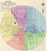
The 1848 charter only specified election of six city-wide councilmembers, but on January 9, 1854, an ordinance was adopted that divided the town into five wards and two councilmen from each ward would be elected to coincide with the completion of the first official city hall. The next election with the new rules on January 15, 1855, decided those first Ward bosses who would serve with the short-term mayor, Allison Nelson. The boundaries were as follows:
- First (yellow): all land west of the W&A Railroad and Whitehall Street. This diverse ward had concentrations of industry and working-class people (such as railroad men) in the northern and western parts but the eastern section was home to some of Atlanta's wealthiest citizens, such as Richard Peters.
- Second (red): land south of Georgia RR between Whitehall and McDonough. This wealthy section included the bulk of the town's wholesalers, warehouses, grocers and hotels. The residential areas included people like Dr. Joseph Thompson.
- Third (green): land south of Georgia RR and east of McDonough. This ward included the new city hall, a number of mills along the railroad and the east many large estates including that of Lemuel P. Grant.
- Fourth (blue): north of Georgia RR and east of Ivy. This ward had two of the roughest sections of town; the red-light district along Decatur Street (including Murrell's Row) and Slabtown but the northern part was home to mostly small farms.
- Fifth (violet): west of Ivy and north of W&A Railroad. This ward contained the large homes along Peachtree Street and the southern part, Fairlie-Poplar was also largely residential with warehousing along the western part.
1866
On March 12, city limits expand to a one-and-a-half mile radius from Union Depot.[2][3]
1871
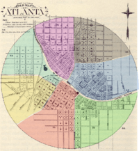
During a huge boom of post-war building, two new wards were added from parts of the First, Fourth and Fifth to reflect the changing look of the city.
- Sixth Ward (aqua): established October 1871 as the half of the First Ward north of Hunter St (MLK). This division left the wealthy in the First ward and gave the working-class people to the north two councilmen of their own.
- Seventh Ward (grey): established December 2, 1871 of parts of the Fourth and Fifth. Specifically from the "junction of Houston and Pryor streets, thence through lot nineteen, between blocks three, one and two, five and six, to the city limits; thence northerly along the city limits to Peachtree Street; thence south along Peachtree Street and Pryor Street to the beginning." And the Fourth was extended "from Ivy Street west to Pryor, and from Houston Street south to the railroad, and that Pryor Street shall be the line between the fourth and fifth wards, and Pryor and Peachtree streets between the fifth and seventh wards." This gave the red-light district to the Fourth and created a new Ward of mostly farmers and to the west, fine residences along Ivy and the east side of Peachtree.
1874
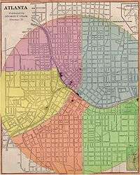
A new city charter was approved by Governor Smith on February 28, 1874, which reduced the number of wards back to five and created a bi-cameral council of two councilmen from each ward and a second body of three at-large aldermen was established. Each year one of the aldermen would be up for election and during his last year in office would serve as president of the other body. They acted separately on finances but together for all other business.
The new ward layout was as follows:
- First Ward (yellow) was bounded by Western & Atlantic Railroad, Foundry St, south around the city limits to modern Peachtree Street
- Second Ward (red) was bounded by the Georgia Railroad, Whitehall south to city limits then north-east to McDonough (Capital Ave) and up to the railroad
- Third Ward (green) was bounded by Butler (Jesse Hill Dr) and McDonough Streets south to the city limits north-east to Georgia RR, then west to Butler
- Fourth Ward (blue) from Pryor and tracks east on Georgia RR to city limits then north west to West Peachtree and south to origin.
- Fifth Ward (purple) from Pryor and tracks north-east to Peachtree, then West Peachtree to city limits, south-west to Foundry and W&A RR and east to origin
1883
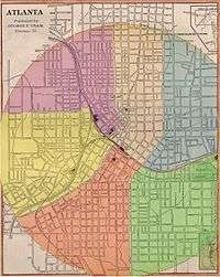
On November 5, 1883 a Sixth Ward (beige) was carved out of the Fourth and Fifth Wards. Its boundaries started at Butler and the GRR (today's Grady Hospital) north to North Ave at Myrtle St, then up Myrtle to the city limit at 3rd St. Follow the arc of the city limit to Williams, south to Cain (International) then James (Church) to Forsyth south to the tracks then east on the tracks to origin. This separated the wealthy Peachtree corridor from the other parts of north Atlanta. (Garrett Vol II, p. 53–54)
1889
Expansion of city limits to one and three-quarters radius from union depot.[2]
1894
When West End was annexed into the city in 1894, it became a new Seventh Ward.
1904
822 acres (333 ha) annexed - the southern part of what is now Midtown was already within the 1889 limits, but in 1904 the city annexes most of the rest of what is now Midtown: this is an area bounded by the 1889 circular city limits on the south, and West Peachtree St. on the west, stretching north up to but not including Ansley Park (roughly 6th to 16th Streets), Piedmont Park, the remainder of Historic Midtown east to what is now the BeltLine. this includes a strip of what is now the Old Fourth Ward between the 1889 limits and the BeltLine.[4]
1905
Further expansion of the city limits was part of a long effort.
In October 1897 Frank P. Rice drove a failed proposal to annex Pittsburgh, Reynoldstown, Bellwood, and what was then called "north Atlanta".[5][6]
"North Atlanta" was defined at the time roughly as today's Midtown, Georgia Tech, and English Avenue:[7]
- today's Midtown between Myrtle St. in the Midtown Historic District and Cherry St., now inside the Georgia Tech campus, as far north as 14th St (then called Wilson Ave.)
- most of what is now the Georgia Tech campus, south of what was then 5th Street
- the area west of Georgia Tech, south of Jefferson St., as far west as Ashby St. (now Lowery Blvd.), including today's English Avenue neighborhood
In 1902 a special committee made a new proposal to annex those areas as well as "Bonnie Brae", Copenhill, and the "St. Charles Avenue" area (in today's Virginia Highland). By then, "north Atlanta" was being referred to as "Peachtree".[8]
In 1905, the Eighth Ward was added. An act of the Georgia General Assembly was enacted on August 3, 1904 which designated the area from then current city limits (at 6th St and West Peachtree), north to 15th St, then east to Piedmont Ave, then northeast to Southern Railway (basically follow Piedmont to the Ansley Park area), then southwardly along the railway the limits. The act also took part of the Sixth Ward north of North Ave. into the new Eighth Ward.
1909
On January 1, 1909, a Ninth Ward was formed out of just annexed Copenhill, part of Druid Hills, Edgewood, Reynoldstown and East Atlanta. Edgewood alone had had its own city government before the annexation.[9]
1910
Annexations
Annexation of 3,510 acres (1,420.45 ha; 5.48 sq mi) to the north and west:[10][11]
- Ansley Park and most of Sherwood Forest
- Peachtree Street from 15h street north to Palisades Road in southern Buckhead
- the area that is now the Georgia Tech campus that was not already part of the city, including the Hemphill Avenue neighborhood
- Bankhead east of the Louisville and Nashville Railroad line
- Remainder of English Avenue (northern part) that was not already part of the city
- Washington Park
- What is now Mozley Park, then called Battle Hill
- Ashview Heights
- remainder of today's West End (western part) that was not already part of the city
- most of Westview
Annexation of 2,011 acres (813.82 ha; 3.14 sq mi) including the town of Oakland City and from the previous city limits south to the BeltLine: Adair Park, most of Pittsburgh, southern Summerhill, southern/eastern edges of Grant Park neighborhood.[11][12]
Annexation of the blocks surrounding Brown Park (now Brownwood Park) in East Atlanta - Moreland east to Stokesland and Glenwood south to the current city limits.[13]
New Tenth Ward
A new Tenth Ward was created. The eastern boundary was McDaniel Street. The southwestern boundary was Whitehall Street to the Central of Georgia Railroad, and from there along the railroad to a point just south of the BeltLine. From there, the boundary ran due west to a prolongation of Holderness Street south of the BeltLine, and from there southwest to the junction of Campbellton and Utoy roads. Then due east along the north boundary of Fort McPherson to the Central of Georgia Railroad. Then south along that railway line to a point between Osborne and Astor avenues, then east to Sylvan Road, then north to the BeltLine, then east to McDaniel Street.[14]
This included:
- New territory from the annexations including Oakland City
- Territory from the Second Ward west of McDaniel Street
- Territory from the Seventh Ward east of the Central of Georgia Railroad
1919
Eleventh Ward created from part of the Ninth Ward (area south of the Georgia railroad line) and from part of the Third Ward. The new ward corresponds to East Atlanta, Ormewood Park, and other adjacent areas.[15]
1922
- Kirkwood[16] annexed (975 acres (394.6 ha; 1.5 sq mi))
- North part of Virginia-Highland and south part of Morningside/Lenox Park annexed (858 acres (347.2 ha; 1.3 sq mi))[17][18]
- Ormewood Park annexed (482 acres (195.1 ha; 0.8 sq mi))[19]
1923
In June 1923 there was a failed movement to annex College Park, East Point, and Hapeville.[20]
1928
- East Lake annexed (717 acres (290.2 ha; 1.1 sq mi))[21] as the 12th ward.
- Chosewood Park annexed. (626 acres (253.3 ha; 1.0 sq mi))[22]
1929
A Thirteenth Ward was created as the section of the Ninth Ward north of St. Charles and east of the Belt Line to the west side of Briarcliff and north the corporate limits. (most of today's Virginia-Highland)
1937
On March 14, 1935, the legislature reduced the number of wards from 13 to 6 and the thirty-nine member city council is cut to eighteen members effective January 1, 1937. The wards were combined as such:
- First: old 2nd & 3rd (south from Central RR to Grant Park)
- Second: old 11th & 12th (southeast: Ormewood, East Atlanta and East Lake)
- Third: old 1st, 5th & 6th (northwest from Central RR around to three blocks east of Peachtree)
- Fourth: old 7th & 10th (from West End to Oakland City)
- Fifth: old 4th & 8th (from Georgia RR up to Piedmont Park and Ansley west of the Belt Line)
- Sixth: old 9th & 13th (everything east of the Belt Line and north of Georgia RR: Inman Park, Druid Hills, etc.)[23]
1952
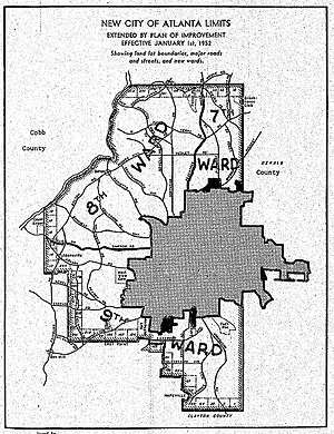
In 1951, after a failed 1947 referendum and two other failed attempts, the state legislature passed a "Plan of Improvement" by which on Jan. 1, 1952, the city annexed 51,470 acres (20,829.2 ha; 80.4 sq mi) in Buckhead, Adams Park, Southwest Atlanta & Lakewood.[24] This was by far the largest expansion in Atlanta's history, tripling the size of the city to 118 square miles (310 km2) and adding 100,000 residents. This helped spread the burden of providing public services by adding to the base a large group of mostly more affluent residents. The annexation was viewed as a triumph of Mayor Hartsfield.[25]
Atlanta would in the 1970s again try, but without success, to repeat the process by state legislation to annex what is now Sandy Springs to Atlanta.[26]
1953
Annexation of Ben Hill, Greenbriar and other adjacent areas in far southwestern Atlanta[27]
1954
The ward system is ended. No longer a bicameral body, only a board of six aldermen with a Vice-Mayor serving as president of the board. All positions were elected city-wide. (For post-ward setup, see Political structure of Atlanta).
Annexations since 1953
Since 1953, multiple small annexations (and deannexations) to the City of Atlanta have occurred, in two periods from 1954-1979 and 2003-2010. No annexations took place from 1979 to 2003.[28]
Multiple small areas adjacent to southwestern Atlanta were annexed including Midwest Cascade, Cascade Glen, and the Horseshoe Community.[29] Sandtown's 2007 petition for annexation was put on hold.[30]
These annexations added a few thousand residents, and approximately three square miles, including areas mostly in the southwest of the city, but also small parcels in the east and north of the city.
References
- Garrett, Franklin Miller (1969). Atlanta and Environs: A Chronicle of Its People and Events. Georgia: University of Georgia Press. ISBN 0-8203-0263-5.
- City Council history
- Stone, Clarence N., Regime Politics Governing Atlanta: 1946–1988, 1989, University Press of Kansas
External links
Notes
- ↑ Atlanta Annexation database, case no. ANX-1958-001
- 1 2 City of Atlanta GIS, Map of Annexations
- ↑ "March 12", This Day in Georgia History, Digital Library of Georgia
- ↑ City of Atlanta annexation database, Case ANX-1904-001
- ↑ ["Suburbs will not be annexed now: The Rice measure tabled by Council yesterday afternoon", Atlanta Constitution, October 27, 1897]
- ↑ John R. Hornady, "Atlanta yesterday, today and tomorrow", 1922
- ↑ ["Outside Folks Hot After Rice", Atlanta Constitution, October 24, 1897]
- ↑ ["New Limits Outlined for Greater Atlanta", Atlanta Constitution, Apr. 30, 1902]
- ↑ Atlanta and Environs: A Chronicle of Its People and Events, 1880s-1930s, Franklin M. Garrett, p.539
- ↑ City of Atlanta annexation database Case ID ANX-1910-004
- 1 2 Annexation Map of Atlanta, City of Atlanta, revised 1981
- ↑ City of Atlanta annexation database Case ID ANX-1910-003
- ↑ City of Atlanta annexation database Case ID ANX-1910-002
- ↑ Atlanta and Environs: A Chronicle of Its People and Events, 1880s-1930s, Franklin M. Garrett p.558
- ↑ Acts passed by the General Assembly of Georgia, 1919, p.834
- ↑ Atlanta annexation database, case ANX-1922-006
- ↑ Atlanta annexation database, case ANX-1922-003
- ↑ Atlanta annexation database, case ANX-1922-002
- ↑ Atlanta annexation database, case ANX-1922-001
- ↑ "Steps are taken for annexation of three suburbs", Atlanta Constitution, June 30, 1923, p.1
- ↑ Atlanta annexation database, case ANX-1928-004
- ↑ Atlanta annexation database, case ANX-1928-001
- ↑ Garrett, Vol. II, p.927
- ↑ City of Atlanta Annexation database, Case ANX-1952-005
- ↑ https://books.google.com/books?id=_WuW4GAUg9EC&lpg=PA71&dq=buckhead%20annexed%20square%20miles&pg=PA86
- ↑ City of Sandy Springs, "History"
- ↑ City of Atlanta annexation database Case ID ANX-1953-001
- ↑ 2, 3, 4, 5 City of Atlanta GIS Annexations database
- ↑ City of Atlanta GIS Annexations database
- ↑ Atlanta annexations database, case ANX-2006-006 Archived April 13, 2014, at the Wayback Machine.