Aritao
| Aritao | ||
|---|---|---|
| Municipality | ||
|
| ||
| ||
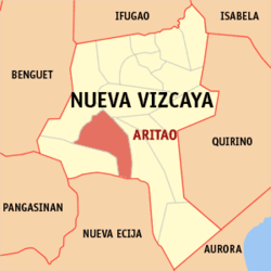
 Map of Nueva Vizcaya showing the location of Aritao | ||
.svg.png) Aritao Location within the Philippines | ||
| Coordinates: 16°18′N 121°02′E / 16.300°N 121.033°ECoordinates: 16°18′N 121°02′E / 16.300°N 121.033°E | ||
| Country | Philippines | |
| Region | Cagayan Valley (Region II) | |
| Province | Nueva Vizcaya | |
| District | Lone district | |
| Barangays | 22 | |
| Government[1] | ||
| • Mayor | Lucing L. Tan | |
| Area[2] | ||
| • Total | 265.60 km2 (102.55 sq mi) | |
| Population (2010)[3] | ||
| • Total | 37,115 | |
| • Density | 140/km2 (360/sq mi) | |
| Time zone | PST (UTC+8) | |
| ZIP code | 3704 | |
| Dialing code | 78 | |
| Income class | 2nd class; partially urban | |
| Website |
aritao | |
Aritao is a second class municipality in the province of Nueva Vizcaya, Philippines. According to the 2010 census, it has a population of 37,115 people.[3]
The ethnic minority called Isinai (the same term for the local spoken dialect) were the original residents of this town. The name Aritao came from the Isinai phrase Ari Tau "which stands for "Our King" (ari=king & tau=our) which refers to the legendary Isinai Chieftain Mengal, a fierce and brave king who resisted Spanish conquest of the Isinai territories around Ajanas and Ynordenan (the areas comprising what is now most of Aritao).
Barangays
Aritao is politically subdivided into 22 barangays.[2]
- Banganan
- Beti
- Bone North
- Bone South
- Calitlitan
- Comon
- Cutar
- Darapidap
- Kirang
- Nagcuartelan
- Poblacion
- Santa Clara
- Tabueng
- Tucanon
- Anayo
- Baan
- Balite
- Canabuan
- Canarem
- Latar-Nocnoc-San Francisco
- Ocao-Capiniaan
- Yaway
History
In 1942, Japanese troops entered Aritao, Nueva Vizcaya.
In 1945, during the liberation at the town of Aritao was fought the battles between the Philippine Commonwealth Army troops of the 2nd, 51st, 52nd, 55th, 56th and 57th Infantry Division of the Philippine Army and the USAFIP-NL 14th Infantry Regiment against the Japanese Imperial forces founded in the Battle of Kirang Pass in the Second World War.
A monument to the gallantry of the Japanese and Filipino soldiers during World War II, located at Barangay Kirang, municipality of Aritao, Nueva Vizcaya, about 50 kilometers from Bayombong. Built in 1978 by the Rakunsankai Society of Japan, it was recently rebuilt using a black glazed stone, and a memorial was engraved in the tablet in Japanese and English. Also offers a scenic view of reforested mountains and hills.
Demographics
| Population census of Aritao | ||
|---|---|---|
| Year | Pop. | ±% p.a. |
| 1990 | 25,942 | — |
| 1995 | 29,151 | +2.21% |
| 2000 | 31,705 | +1.82% |
| 2007 | 34,206 | +1.05% |
| 2010 | 37,115 | +3.01% |
| Source: National Statistics Office[3] | ||
Schools
- Aritao High School
- Immaculate Conception Academy
- Saint Teresita's Academy
- Nueva Vizcaya Institute
- Santa Clara High School
Aritao also has a lot of schools for primary (elementary education). And for the college level, the Colegio de Aritao is for vocational courses like caregiving. It is located at the Saint Teresita's Academy campus.
Images
-
Aritao Townhall and Town Plaza
-
Saint Joseph, Husband of Mary Parish Church
-
Nueva Vizcaya Institute
-
Twin (Skull and Salakot) mountains (visible from Aritao Townhall)
References
- ↑ "Official City/Municipal 2013 Election Results". Intramuros, Manila, Philippines: Commission on Elections (COMELEC). 11 September 2013. Retrieved 19 December 2013.
- 1 2 "Province: NUEVA VIZCAYA". PSGC Interactive. Makati City, Philippines: National Statistical Coordination Board. Retrieved 19 December 2013.
- 1 2 3 "Total Population by Province, City, Municipality and Barangay: as of May 1, 2010" (PDF). 2010 Census of Population and Housing. National Statistics Office. Archived from the original (PDF) on 14 November 2013. Retrieved 19 December 2013.
External links
| Wikimedia Commons has media related to Aritao, Nueva Vizcaya. |
- Philippine Standard Geographic Code
- Philippine Census Information
- Local Governance Performance Management System
 |
Bambang |  | ||
| Kayapa | |
Dupax del Sur | ||
| ||||
| | ||||
| Santa Fe | Carranglan, Nueva Ecija |
