Appleton-le-Street with Easthorpe
| Appleton le Street with Easthorpe | |
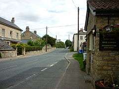
 Main road which runs through Appleton le Street |
|
 Appleton le Street with Easthorpe |
|
| Population | 122 |
|---|---|
| OS grid reference | SE 73657 73524 |
| District | Ryedale |
| Shire county | North Yorkshire |
| Region | Yorkshire and the Humber |
| Country | England |
| Sovereign state | United Kingdom |
| Post town | Malton |
| Dialling code | 01653 |
| Police | North Yorkshire |
| Fire | North Yorkshire |
| Ambulance | Yorkshire |
| EU Parliament | Yorkshire and the Humber |
| UK Parliament | Thirsk and Malton (formerly Ryedale) |
Coordinates: 54°09′07″N 0°52′21″W / 54.15198°N 0.872383°W
May2006.jpg)
Appleton-le-Street with Easthorpe is a civil parish in the Ryedale district of North Yorkshire, England, consisting of Appleton-le-Street and Easthorpe. The parish contains the townships of Swinton, Broughton, Hildenley with a chapel at Amotherby called All Saints.[1] The parish also lies just north of the River Rye. The parish had a population of 117 according to the 2001 census. According to the 2011 Census the population is now 122.[2]
Appleton le Street is in the district of Ryedale and lies just 4 miles west of the town Malton. Easthorpe is a small village south of Appleton le Street and 3 miles from Malton.
In the 1870s Appleton le Street was described as:
- "a township and a parish in Malton district, N. R. Yorkshire. The township lies on the Roman road to Aldborough, near the river Rye, 3½ miles WNW of New Malton r. station. Acres, 1,140. Real property, £1,815. Pop., 185. Houses, 36."[3]
Population

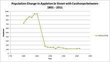
As you can see from the graph, between the years of 1801 and 1851, the Parish of Appleton le Street with Easthorpe had a very high population of between 730 and 940. But since the release of the next available population census statistics in 1881, all the way up to 2011, a huge drop in the number of residents in the parish of Appleton le Street with Easthorpe can be seen, with there only being a population between 120 and 170.[4] There are reasons for this huge decline in population in the mid 19th century. One reasons is due to the growth of North-East England in the mid 19th century, and the cause for this increase was mining and new heavy industries in the area, thus decreasing the population of small parishes in North Yorkshire, such as Appleton le Street with Easthorpe, because the majority of the population needed to move with the work, and moving to the city would be more economically stable for families.[5]
History
In the area of Appleton le Street with Easthorpe lies the notable All Saints church. The church is situated just north of Easthorpe in Appleton le Street itself. The church is a Grade I listed Saxon church which escaped improvement by the Victorians.[6] The earliest written reference to a church at Appleton exists in a charter of King Henry II (1154–1189). It is curiously omitted from the Domesday Book, yet it is beyond dispute that there was a church at that time. The first reference in the register to Appleton is on 20 September 1232 when a Mr. Stephen de (Eglefeld?) was instituted as first rector.[7] Inside, effigies date from the 13th and 14th centuries and some interior woodwork dates from 1636.[8]
The place Appleton le Street originally translates to, Apple orchard on a Roman road. Appleton in old Roman times simply translates to an orchard, le, translates to 'the' in old French and the word street in old Roman times translates to a Roman road.[9] Easthorpe directly translates to, East outlying farm or settlement. With east simply translating to eastern, and thorpe directly translating to, a secondary settlement and a dependent outlying farm or hamlet.[10]
Occupational structure

From the pie chart shown, you can see that the majority of people worked as labourers and servants, and just under 25% of the population were middling sorts, small farmers not employing labourers, with both masters and skilled workers in urban manufacturing and handicrafts. Then there were around 30 professionals and employers in 1831.
And then in 1881, the amount of professionals had decreased to three people, one male and two females. The majority of men in 1881 still worked on agriculture, whilst the majority of women worked in the 'Unknown Sector'. The men mostly worked in hard labour jobs whilst women worked in more domestic occupations.[11]
Housing

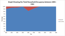
As you can see from the line graph showing the total number of houses, between the years of around 1831 and 1851, the total number of houses were between 196 and 210 respectively,[12] and from the graph showing the house occupancy, you can see that just below 90% were occupied in 1831, which is means there was 21 vacant at the time, but as get closer to 1851, the vacant number of homes decreases, to only 9.[13]

As you progress down the years past 1851, there is a similar trend to population as there is to the total number of houses, with the number decreasing rapidly to only 34 in 1881, and this number is stable all the way through to 1961 where the total number of homes is 36. However, as you can see from the total occupancy graph there is no vacant houses in 1881 but then by 1891 only around 75% of the houses are occupied, with 8 homes being vacant, until around 1921, then all the houses are occupied again all the way up to 1961.[14]
Amenities
Cresswell Arms

Within the Parish of Appleton le Street with Easthorpe are 2 hotels and lodges. In the area of Appleton le Street itself lies Cresswell Arms. Cresswell Arms is a traditional country inn dating back to the 1800s when it was flanked by a blacksmith and a butcher, and lies just on the edge of the North York Moors.[15]
References
- ↑ "Appleton le Street Parish History". Family Search. Retrieved 25 February 2013.
- ↑ "Appleton-le-Street with Easthorpe (parish)". Neighbourhood Statistics. Office for National Statistics. 30 January 2013. Retrieved 1 December 2015.
- ↑ Wilson, John (1870–72). Imperial Gazetteer of England and Wales. A. Fullarton and Co. Retrieved 4 February 2013.
- ↑ "Appleton le Street with Easthorpe Population Statistics". A Vision of Britain through Time. Retrieved 25 February 2013.
- ↑ "Change in Population for Appleton le Street with Easthorpe". A Vision of Britain through Time. Retrieved 25 February 2013.
- ↑ "All Saints Church". A Church Near You. Retrieved 26 February 2013.
- ↑ "All Saints Church History". The Street Parishes. Retrieved 26 February 2013.
- ↑ "All Saints Church". Timaps. Retrieved 26 February 2013.
- ↑ "Appleton le Street History". Institute for Names Studies – Nottingham University. Retrieved 1 March 2013.
- ↑ "Easthorpe History". Institute for Names Studies – Nottingham University. Retrieved 1 March 2013.
- ↑ "Occupational Structure". Vision of Britain. Retrieved 22 March 2013.
- ↑ "Household". Vision of Britain. Retrieved 25 March 2013.
- ↑ "Households". Vision of Britain. Retrieved 25 March 2013.
- ↑ "Household". Vision of Britain. Retrieved 25 March 2013.
- ↑ "Cresswell Arms". Cresswell Arms. Retrieved 5 March 2013.