Ūla
| Ūla | |
|---|---|
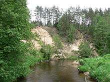 A bend in the river Ūla | |
| Country | Lithuania and Belarus |
| Basin | |
| Main source | Grodno Region |
| River mouth | Merkys |
| Basin size | 753 km2 (291 sq mi) |
| Physical characteristics | |
| Length | 84 km (52 mi) |
| Discharge |
|
The Ūla (Belarusian: Ула) is a river in Dzūkija National Park in southern Lithuania and northern Belarus.
Its total length is 84 km. The Ūla flows into the Merkys.
The river is mostly shallow, with colorful water foliage flowing near the surface. It has numerous bends, rocks and steep sandy shores. All of this makes Ūla one of the most beautiful rivers in Lithuania and a popular, albeit a bit difficult canoeing destination.
Coordinates: 54°09′50″N 24°20′11″E / 54.16389°N 24.33639°E
This article is issued from Wikipedia - version of the 6/21/2016. The text is available under the Creative Commons Attribution/Share Alike but additional terms may apply for the media files.